Weather Alert in Iowa
Winter Weather Advisory issued February 19 at 2:41AM CST until February 20 at 6:00AM CST by NWS La Crosse WI
AREAS AFFECTED: Allamakee; Fayette; Clayton; Monroe; Juneau; Adams; Vernon; Crawford; Richland; Grant
DESCRIPTION: ...A QUICK HITTING BAND OF HEAVY SNOW TONIGHT WILL LEAD TO SLIPPERY TRAVEL CONDITIONS... .A band of snow develops across northeast Iowa into southwest Wisconsin this evening and lasts through the overnight, departing around sunrise. The snow will be heavy at times with rates exceeding 1" per hour and quickly lead to snow-covered and slippery roads. The heaviest snow is forecast to fall in a relatively narrow band with amounts quickly decreasing on either side of the band, making this snowfall forecast on the challenging side. Any small changes to the placement of the snow band could change forecast snow amounts at a given location very quickly. * WHAT...Snow with total accumulations between 2 and 5 inches. A narrow corridor of 6 inches is possible within the advisory, but confidence in its placement is low at this time. * WHERE...Portions of northeast Iowa and central, southwest, and west central Wisconsin. * WHEN...From 8 PM this evening to 6 AM CST Friday. * IMPACTS...Plan on slippery road conditions.
INSTRUCTION: Slow down and use caution while traveling. In Iowa, visit 511ia.org for road conditions. In Wisconsin, visit 511wi.gov for road conditions.
Want more detail? Get the Complete 7 Day and Night Detailed Forecast!
Current U.S. National Radar--Current
The Current National Weather Radar is shown below with a UTC Time (subtract 5 hours from UTC to get Eastern Time).

National Weather Forecast--Current
The Current National Weather Forecast and National Weather Map are shown below.

National Weather Forecast for Tomorrow
Tomorrow National Weather Forecast and Tomorrow National Weather Map are show below.

North America Water Vapor (Moisture)
This map shows recent moisture content over North America. Bright and colored areas show high moisture (ie, clouds); brown indicates very little moisture present; black indicates no moisture.

Weather Topic: What is Graupel?
Home - Education - Precipitation - Graupel
 Next Topic: Hail
Graupel is a form of precipitation that is created by atmospheric conditions
which cause supercooled water droplets to contact snow crystals and freeze to
their surface.
Sometimes known as soft hail or snow pellets, graupel is delicate and easily
destroyed by touch. Whereas hail usually falls during severe weather, graupel
doesn't require such conditions to form, and can form in mild precipitation
similar to situations which produce snowfall.
Next Topic: Hail
Weather Topic: What are Hole Punch Clouds?
Home - Education - Cloud Types - Hole Punch Clouds
 Next Topic: Mammatus Clouds
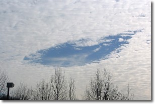
A hole punch cloud is an unusual occurrence when a disk-shaped
hole appears in a cirrostratus, cirrocumulus, or altocumulus cloud.
When part of the cloud forms ice crystals, water droplets in the surrounding area
of the cloud evaporate. The effect of this process produces a large elliptical
gap in the cloud. The hole punch cloud formation is rare, but it is not specific
to any geographic area.
Other names which have been used to describe this phenomena include fallstreak hole,
skypunch, and cloud hole.
Next Topic: Mammatus Clouds
Current conditions powered by WeatherAPI.com


