Weather Alert in Maine
Special Weather Statement issued August 23 at 5:53AM EDT by NWS Gray ME
AREAS AFFECTED: Interior York; Central Interior Cumberland; Androscoggin; Kennebec; Interior Waldo; Coastal York; Coastal Cumberland; Sagadahoc; Lincoln; Knox; Coastal Waldo; Interior Cumberland Highlands; Strafford; Eastern Hillsborough; Interior Rockingham; Coastal Rockingham
DESCRIPTION: A dry air mass and breezy conditions will combine with very dry fuels such as grass, leaves, and twigs to create the potential for uncontrolled fire spread across coastal and interior Maine and southeast New Hampshire today. This afternoon, relative humidity values will decrease to levels between 30 to 40 percent. At the same time, southerly winds 10 to 15 mph with frequent gusts to 25 mph will continue to dry fuels and increase fire spread potential. Wind gusts are expected to slacken later this evening, but winds will remain breezy overnight. Extra caution should be taken to prevent wildfires. Always consult with fire officials before engaging in any open burning activities and comply with all applicable laws and regulations. Never leave an open fire unattended and always extinguish campfires completely before leaving.
INSTRUCTION: N/A
Want more detail? Get the Complete 7 Day and Night Detailed Forecast!
Current U.S. National Radar--Current
The Current National Weather Radar is shown below with a UTC Time (subtract 5 hours from UTC to get Eastern Time).

National Weather Forecast--Current
The Current National Weather Forecast and National Weather Map are shown below.

National Weather Forecast for Tomorrow
Tomorrow National Weather Forecast and Tomorrow National Weather Map are show below.

North America Water Vapor (Moisture)
This map shows recent moisture content over North America. Bright and colored areas show high moisture (ie, clouds); brown indicates very little moisture present; black indicates no moisture.

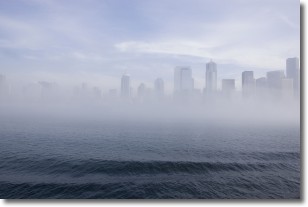
Weather Topic: What is Fog?
Home - Education - Cloud Types - Fog
 Next Topic: Fractus Clouds
Fog is technically a type of stratus cloud, which lies along the
ground and obscures visibility.
It is usually created when humidity in the air condenses into tiny water droplets.
Because of this, some places are more prone to foggy weather, such as regions
close to a body of water.
Fog is similar to mist; both are the appearance of water droplets suspended in
the air, but fog is the term applied to the condition when visibility is less than 1 km.
Next Topic: Fractus Clouds
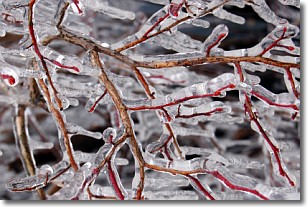
Weather Topic: What is Freezing Rain?
Home - Education - Precipitation - Freezing Rain
 Next Topic: Graupel
Freezing rain is a condition where precipitation which has fallen in the form of
water droplets reaches temperatures which are below freezing and freezes upon
coming into contact
with surface objects. The result of this precipitation is a glaze of ice which
can be damaging to plants and man-made structures. A severe onset of freezing
rain which results in a very thick glaze of ice is known as an ice storm.
Next Topic: Graupel
Current conditions powered by WeatherAPI.com


