Weather Alert in Kentucky
Special Weather Statement issued September 5 at 10:56PM EDT by NWS Jackson KY
AREAS AFFECTED: Rockcastle; Jackson; Pulaski; Laurel; Lee; Breathitt; Owsley; Perry; Clay
DESCRIPTION: At 1055 PM EDT, Doppler radar was tracking strong thunderstorms along a line extending from Mummie to Peoples to near Billows to Somerset Pulaski Airport. Movement was east at 35 mph. HAZARD...Wind gusts up to 50 mph and pea size hail. SOURCE...Radar indicated. IMPACT...Gusty winds could knock down tree limbs and blow around unsecured objects. Minor hail damage to vegetation is possible. Locations impacted include... Somerset, London, Mount Vernon, Manchester, McKee, Booneville, Buckhorn, Turin, Donaro, Travellers Rest, Fariston, Southfork, Cowcreek, Shop Branch, Fogertown, Tyner, Privett, Earnestville, Mount Victory, and Mershons. THIS INCLUDES THE FOLLOWING HIGHWAYS... Hal Rogers Parkway between mile markers 1 and 17. Interstate 75 in east central Kentucky between mile markers 33 and 59. Kentucky Highway 80 in Laurel County between mile markers 1 and 11. Kentucky Highway 80 in Pulaski County between mile markers 17 and 40. Louis B. Nunn Parkway
INSTRUCTION: If outdoors, consider seeking shelter inside a building. Torrential rainfall is also occurring with these storms and may lead to localized flooding. Do not drive your vehicle through flooded roadways. Frequent cloud to ground lightning is occurring with these storms. Lightning can strike 10 miles away from a thunderstorm. Seek a safe shelter inside a building or vehicle. A Severe Thunderstorm Watch remains in effect until 100 AM EDT for south central and southeastern Kentucky.
Want more detail? Get the Complete 7 Day and Night Detailed Forecast!
Current U.S. National Radar--Current
The Current National Weather Radar is shown below with a UTC Time (subtract 5 hours from UTC to get Eastern Time).

National Weather Forecast--Current
The Current National Weather Forecast and National Weather Map are shown below.

National Weather Forecast for Tomorrow
Tomorrow National Weather Forecast and Tomorrow National Weather Map are show below.

North America Water Vapor (Moisture)
This map shows recent moisture content over North America. Bright and colored areas show high moisture (ie, clouds); brown indicates very little moisture present; black indicates no moisture.

Weather Topic: What are Stratus Clouds?
Home - Education - Cloud Types - Stratus Clouds
 Next Topic: Wall Clouds
Stratus clouds are similar to altostratus clouds, but form at a
lower altitude and are identified by their fog-like appearance, lacking the
distinguishing features of most clouds.
Stratus clouds are wider than most clouds, and their base has a smooth, uniform
look which is lighter in color than a nimbostratus cloud.
The presence of a stratus cloud indicates the possibility of minor precipitation,
such as drizzle, but heavier precipitation does not typically arrive in the form
of a stratus cloud.
Next Topic: Wall Clouds
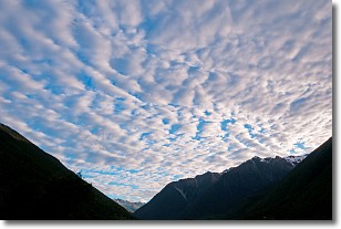
Weather Topic: What are Altocumulus Clouds?
Home - Education - Cloud Types - Altocumulus Clouds
 Next Topic: Altostratus Clouds
Similar to cirrocumulus clouds, altocumulus clouds are
characterized by cloud patches. They are distinguished by larger cloudlets
than cirrocumulus clouds but are still smaller than stratocumulus clouds.
Altocumulus clouds most commonly form in middle altitudes (between 2 and 5 km)
and may resemble, at times, the shape of a flying saucer.
These uncommon formations, called altocumulus lenticularis, are created by uplift
in the atmosphere and are most often seen in close proximity to mountains.
Next Topic: Altostratus Clouds
Current conditions powered by WeatherAPI.com


