Weather Alert in Illinois
Flood Warning issued July 28 at 9:15PM CDT until July 31 at 1:00PM CDT by NWS St Louis MO
AREAS AFFECTED: Calhoun, IL; Pike, MO
DESCRIPTION: ...The Flood Warning is extended for the following rivers in Illinois...Missouri... Mississippi River at Saverton. Mississippi River at Hannibal. ...The Flood Warning continues for the following rivers in Illinois...Missouri... Mississippi River at Winfield. Mississippi River at Clarksville. Mississippi River at Louisiana. Middle Fabius River near Ewing. ...The Flood Warning is cancelled for the following rivers in Missouri... North Fabius River near Ewing. River forecasts are based on observed precipitation and forecast precipitation for the next 24 hours. * WHAT...Minor flooding is occurring and minor flooding is forecast. * WHERE...Mississippi River at Clarksville. * WHEN...Until Thursday afternoon. * IMPACTS...At 27.2 feet, Silo Park just northwest of Clarksville off Highway 79 begins flooding. * ADDITIONAL DETAILS... - At 9:00 PM CDT Monday the stage was 26.4 feet. - Recent Activity...The maximum river stage in the 24 hours ending at 9:00 PM CDT Monday was 26.4 feet. - Forecast...The river is expected to fall below flood stage Wednesday morning and continue falling to 22.7 feet Monday, August 04. - Flood stage is 25.0 feet.
INSTRUCTION: Turn around, don't drown when encountering flooded roads. Most flood deaths occur in vehicles. This product, along with additional weather and stream information, is available at https://water.noaa.gov/wfo/lsx
Want more detail? Get the Complete 7 Day and Night Detailed Forecast!
Current U.S. National Radar--Current
The Current National Weather Radar is shown below with a UTC Time (subtract 5 hours from UTC to get Eastern Time).

National Weather Forecast--Current
The Current National Weather Forecast and National Weather Map are shown below.

National Weather Forecast for Tomorrow
Tomorrow National Weather Forecast and Tomorrow National Weather Map are show below.

North America Water Vapor (Moisture)
This map shows recent moisture content over North America. Bright and colored areas show high moisture (ie, clouds); brown indicates very little moisture present; black indicates no moisture.

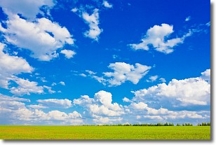
Weather Topic: What are Cumulus Clouds?
Home - Education - Cloud Types - Cumulus Clouds
 Next Topic: Drizzle
Cumulus clouds are fluffy and textured with rounded tops, and
may have flat bottoms. The border of a cumulus cloud
is clearly defined, and can have the appearance of cotton or cauliflower.
Cumulus clouds form at low altitudes (rarely above 2 km) but can grow very tall,
becoming cumulus congestus and possibly the even taller cumulonimbus clouds.
When cumulus clouds become taller, they have a greater chance of producing precipitation.
Next Topic: Drizzle
Weather Topic: What is Evaporation?
Home - Education - Precipitation - Evaporation
 Next Topic: Fog
Evaporation is the process which returns water from the earth
back to the atmosphere, and is another crucial process in the water cycle.
Evaporation is the transformation of liquid into gas, and it happens because
molecules are excited by the application of energy and turn into vapor.
In order for water to evaporate it has to be on the surface of a body of water.
Next Topic: Fog
Current conditions powered by WeatherAPI.com


