Weather Alert in Michigan
Special Weather Statement issued August 23 at 7:47PM EDT by NWS Detroit/Pontiac MI
AREAS AFFECTED: Livingston; Oakland; Macomb; Washtenaw; Wayne
DESCRIPTION: At 747 PM EDT, Doppler radar was tracking strong thunderstorms along a line extending from West Bloomfield to near Salem to near Dexter. Movement was east at 40 mph. HAZARD...Winds in excess of 40 mph. SOURCE...Radar indicated. IMPACT...Gusty winds could knock down tree limbs and blow around unsecured objects. Strong thunderstorms will be near... Ann Arbor, Livonia, Southfield, Novi, Canton, Birmingham, Northville, and Dixboro around 750 PM EDT. Troy, Ypsilanti, and Royal Oak around 755 PM EDT. Dearborn and Detroit Zoo around 800 PM EDT. Warren, Romulus, Sterling Heights, and Greenfield Village around 805 PM EDT. Taylor, Detroit, and Belleville around 810 PM EDT. St. Clair Shores, Downtown Detroit, Wyandotte, and Belle Isle around 820 PM EDT. Grosse Pointe around 825 PM EDT. Trenton around 835 PM EDT. Other locations impacted by these storms include Franklin, Keego Harbor, Melvindale, Harper Woods, Westland, Pleasant Ridge, Grosse Pointe Shores, Huntington Woods, Wolverine Lake, and Woodhaven. People attending Clawson Fest , Novi Taco Fest and Art , Freedom Hill Amphitheatre , and Comerica Park should seek safe shelter immediately!
INSTRUCTION: If outdoors, consider seeking shelter inside a building.
Want more detail? Get the Complete 7 Day and Night Detailed Forecast!
Current U.S. National Radar--Current
The Current National Weather Radar is shown below with a UTC Time (subtract 5 hours from UTC to get Eastern Time).

National Weather Forecast--Current
The Current National Weather Forecast and National Weather Map are shown below.

National Weather Forecast for Tomorrow
Tomorrow National Weather Forecast and Tomorrow National Weather Map are show below.

North America Water Vapor (Moisture)
This map shows recent moisture content over North America. Bright and colored areas show high moisture (ie, clouds); brown indicates very little moisture present; black indicates no moisture.

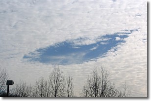
Weather Topic: What are Hole Punch Clouds?
Home - Education - Cloud Types - Hole Punch Clouds
 Next Topic: Mammatus Clouds
A hole punch cloud is an unusual occurrence when a disk-shaped
hole appears in a cirrostratus, cirrocumulus, or altocumulus cloud.
When part of the cloud forms ice crystals, water droplets in the surrounding area
of the cloud evaporate. The effect of this process produces a large elliptical
gap in the cloud. The hole punch cloud formation is rare, but it is not specific
to any geographic area.
Other names which have been used to describe this phenomena include fallstreak hole,
skypunch, and cloud hole.
Next Topic: Mammatus Clouds
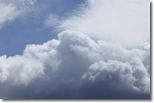
Weather Topic: What are Nimbostratus Clouds?
Home - Education - Cloud Types - Nimbostratus Clouds
 Next Topic: Precipitation
A nimbostratus cloud is similar to a stratus cloud in its formless,
smooth appearance. However, a nimbostratus cloud is darker than a stratus cloud,
because it is thicker.
Unlike a stratus cloud, a nimbostratus cloud typically brings with it the threat
of moderate to heavy precipitation. In some cases, the precipitation may evaporate
before reaching the ground, a phenomenon known as virga.
Next Topic: Precipitation
Current conditions powered by WeatherAPI.com


