Weather Alert in California
Winter Weather Advisory issued February 21 at 12:49PM PST until February 22 at 4:00PM PST by NWS Medford OR
AREAS AFFECTED: Western Siskiyou County; South Central Siskiyou County; North Central and Southeast Siskiyou County
DESCRIPTION: * WHAT...Snow expected above 4500 feet in Siskiyou County. Total snow accumulations 3 to 6 inches. Winds gusting as high as 60 mph over high and exposed terrain. * WHERE...Above 4500 feet in Siskiyou County Including the locations of...Bray, Tennant. This also includes the following passes or notable locations... Dead Horse Summit on State Highway 89 at 4489 ft. Etna Summit on Sawyers Bar Rd at 5950 ft. Mt. Shasta ski park highway around 5400 ft. Grass Lake at Mt. Hebron at 5291 ft. Bunny Flat on Everitt Memorial highway at 6900 ft. * WHEN...From 10 PM this evening to 4 PM PST Sunday. * IMPACTS...Travel may be very difficult to impossible. Strong winds could cause tree damage and low visibility. * ADDITIONAL DETAILS... Visit weather.gov/mfr/winter for additional snow probabilities
INSTRUCTION: Slow down and use caution while traveling. Call 511 or visit quickmap.dot.ca.gov for road information.
Want more detail? Get the Complete 7 Day and Night Detailed Forecast!
Current U.S. National Radar--Current
The Current National Weather Radar is shown below with a UTC Time (subtract 5 hours from UTC to get Eastern Time).

National Weather Forecast--Current
The Current National Weather Forecast and National Weather Map are shown below.

National Weather Forecast for Tomorrow
Tomorrow National Weather Forecast and Tomorrow National Weather Map are show below.

North America Water Vapor (Moisture)
This map shows recent moisture content over North America. Bright and colored areas show high moisture (ie, clouds); brown indicates very little moisture present; black indicates no moisture.

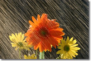
Weather Topic: What is Precipitation?
Home - Education - Precipitation - Precipitation
 Next Topic: Rain
Precipitation can refer to many different forms of water that
may fall from clouds. Precipitation occurs after a cloud has become saturated to
the point where its water particles are more dense than the air below the cloud.
In most cases, precipitation will reach the ground, but it is not uncommon for
precipitation to evaporate before it reaches the earth's surface.
When precipitation evaporates before it contacts the ground it is called Virga.
Graupel, hail, sleet, rain, drizzle, and snow are forms of precipitation, but fog
and mist are not considered precipitation because the water vapor which
constitutes them isn't dense enough to fall to the ground.
Next Topic: Rain
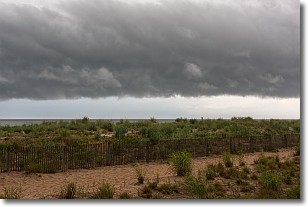
Weather Topic: What are Shelf Clouds?
Home - Education - Cloud Types - Shelf Clouds
 Next Topic: Sleet
A shelf cloud is similar to a wall cloud, but forms at the front
of a storm cloud, instead of at the rear, where wall clouds form.
A shelf cloud is caused by a series of events set into motion by the advancing
storm; first, cool air settles along the ground where precipitation has just fallen.
As the cool air is brought in, the warmer air is displaced, and rises above it,
because it is less dense. When the warmer air reaches the bottom of the storm cloud,
it begins to cool again, and the resulting condensation is a visible shelf cloud.
Next Topic: Sleet
Current conditions powered by WeatherAPI.com


