Weather Alert in Idaho
Avalanche Advisory issued February 21 at 5:55AM MST by NWS Pocatello ID
AREAS AFFECTED: Bear River Range
DESCRIPTION: SABPIH The following message is transmitted at the request of the Forest Service Utah Avalanche Center. The Forest Service Utah Avalanche Center has issued a SPECIAL AVALANCHE BULLETIN for the following areas: * WHAT...Dangerous avalanche conditions are possible across the Bear River Range and surrounding mountains across northern Utah this weekend. This week's heavy snowfall and strong winds overloaded preexisting weak layers, creating HIGH avalanche danger. With improving weather moving in for the weekend, avalanche accidents are likely in the backcountry. There have already been two avalanche fatalities this week, as well as several close calls and numerous backcountry avalanches reported. * WHERE...Bear River Range and surrounding mountains across northern Utah. * WHEN...6 AM MST Monday. * IMPACTS...Dangerous avalanche conditions exist in the mountains and will persist through the weekend.
INSTRUCTION: Natural avalanches are possible, and people are likely to trigger avalanches on slopes steeper than 30 degrees. Dangerous and deadly avalanches can be triggered remotely from a distance or from below. People leaving ski area boundaries are entering the backcountry where the same dangerous avalanche conditions exist. Consult www.utahavalanchecenter.org or www.avalanche.org for more detailed information. Similar avalanche danger may exist at locations outside the coverage area of this or any avalanche center.
Want more detail? Get the Complete 7 Day and Night Detailed Forecast!
Current U.S. National Radar--Current
The Current National Weather Radar is shown below with a UTC Time (subtract 5 hours from UTC to get Eastern Time).

National Weather Forecast--Current
The Current National Weather Forecast and National Weather Map are shown below.

National Weather Forecast for Tomorrow
Tomorrow National Weather Forecast and Tomorrow National Weather Map are show below.

North America Water Vapor (Moisture)
This map shows recent moisture content over North America. Bright and colored areas show high moisture (ie, clouds); brown indicates very little moisture present; black indicates no moisture.

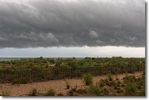
Weather Topic: What are Shelf Clouds?
Home - Education - Cloud Types - Shelf Clouds
 Next Topic: Sleet
A shelf cloud is similar to a wall cloud, but forms at the front
of a storm cloud, instead of at the rear, where wall clouds form.
A shelf cloud is caused by a series of events set into motion by the advancing
storm; first, cool air settles along the ground where precipitation has just fallen.
As the cool air is brought in, the warmer air is displaced, and rises above it,
because it is less dense. When the warmer air reaches the bottom of the storm cloud,
it begins to cool again, and the resulting condensation is a visible shelf cloud.
Next Topic: Sleet
Weather Topic: What is Snow?
Home - Education - Precipitation - Snow
 Next Topic: Stratocumulus Clouds
Snow is precipitation taking the form of ice crystals. Each ice crystal, or snowflake,
has unique characteristics, but all of them grow in a hexagonal structure.
Snowfall can last for sustained periods of time and result in significant buildup
of snow on the ground.
On the earth's surface, snow starts out light and powdery, but as it begins to melt
it tends to become more granular, producing small bits of ice which have the consistency of
sand. After several cycles of melting and freezing, snow can become very dense
and ice-like, commonly known as snow pack.
Next Topic: Stratocumulus Clouds
Current conditions powered by WeatherAPI.com


