Weather Alert in Montana
Avalanche Warning issued February 24 at 5:21AM MST by NWS Billings MT
AREAS AFFECTED: Absaroka/Beartooth Mountains
DESCRIPTION: AVWBYZ The following message is transmitted at the request of the Gallatin National Forest Avalanche Center. The Gallatin NF Avalanche Center in Bozeman has issued a BACKCOUNTRY AVALANCHE WARNING for the following areas: NWS Billings MT - MTZ067 (MTZ067) * WHAT...The Gallatin National Forest Avalanche Center has issued an AVALANCHE WARNING for the Cooke City area. Heavy snowfall and strong winds are rapidly loading weak layers in the snowpack, creating very dangerous avalanche conditions. Human-triggered and natural avalanches are likely. Avoid travel on and underneath slopes steeper than 30 degrees. The avalanche danger is HIGH on all slopes. * WHERE...The mountains in and around Cooke City. * WHEN...In effect from Tue 05:00 MST to Wed 05:00 MST. * IMPACTS...Heavy snowfall and strong winds are creating unstable conditions over wide areas. * PRECAUTIONARY / PREPAREDNESS ACTIONS...Very dangerous avalanche conditions. Backcountry travelers should stay off and out from under slopes steeper than 30 degrees. Avalanches can be triggered from flat terrain above, below, and to the side of steep slopes. Avalanches will run into lower-angled terrain. Consult http://www.mtavalanche.com or www.avalanche.org for more detailed information. Similar avalanche danger may exist at locations outside the coverage area of this or any avalanche center.
INSTRUCTION: N/A
Want more detail? Get the Complete 7 Day and Night Detailed Forecast!
Current U.S. National Radar--Current
The Current National Weather Radar is shown below with a UTC Time (subtract 5 hours from UTC to get Eastern Time).

National Weather Forecast--Current
The Current National Weather Forecast and National Weather Map are shown below.

National Weather Forecast for Tomorrow
Tomorrow National Weather Forecast and Tomorrow National Weather Map are show below.

North America Water Vapor (Moisture)
This map shows recent moisture content over North America. Bright and colored areas show high moisture (ie, clouds); brown indicates very little moisture present; black indicates no moisture.

Weather Topic: What is Snow?
Home - Education - Precipitation - Snow
 Next Topic: Stratocumulus Clouds
Snow is precipitation taking the form of ice crystals. Each ice crystal, or snowflake,
has unique characteristics, but all of them grow in a hexagonal structure.
Snowfall can last for sustained periods of time and result in significant buildup
of snow on the ground.
On the earth's surface, snow starts out light and powdery, but as it begins to melt
it tends to become more granular, producing small bits of ice which have the consistency of
sand. After several cycles of melting and freezing, snow can become very dense
and ice-like, commonly known as snow pack.
Next Topic: Stratocumulus Clouds
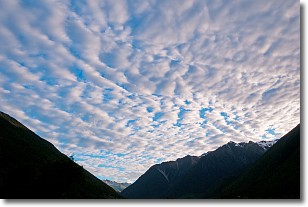
Weather Topic: What are Stratus Clouds?
Home - Education - Cloud Types - Stratus Clouds
 Next Topic: Wall Clouds
Stratus clouds are similar to altostratus clouds, but form at a
lower altitude and are identified by their fog-like appearance, lacking the
distinguishing features of most clouds.
Stratus clouds are wider than most clouds, and their base has a smooth, uniform
look which is lighter in color than a nimbostratus cloud.
The presence of a stratus cloud indicates the possibility of minor precipitation,
such as drizzle, but heavier precipitation does not typically arrive in the form
of a stratus cloud.
Next Topic: Wall Clouds
Current conditions powered by WeatherAPI.com


