Weather Alert in Kansas
Hydrologic Outlook issued August 27 at 8:01AM CDT by NWS Topeka KS
AREAS AFFECTED: Lyon, KS
DESCRIPTION: ESFTOP Cottonwood River near Emporia This hydrologic outlook is based on the forecast rainfall for the next 24 hours and estimated runoff from earlier rainfall. Crests may vary if actual rainfall or runoff is greater or less than anticipated. Location: Cottonwood River near Emporia Flood stage: 20.0 feet Latest stage: 2.6 feet at 7 AM Wednesday Maximum Forecast Stage: 22.7 feet at 7 PM Friday Aug 29 Fld Obs Forecasts Location Stg Stg Day/Time Wed Thu Fri 1pm 1pm 1pm Cottonwood River Emporia 20.0 2.6 Wed 7am 2.6 13.5 22.5 Later statements, possibly warnings, may be issued as additional information becomes available.
INSTRUCTION: N/A
Want more detail? Get the Complete 7 Day and Night Detailed Forecast!
Current U.S. National Radar--Current
The Current National Weather Radar is shown below with a UTC Time (subtract 5 hours from UTC to get Eastern Time).

National Weather Forecast--Current
The Current National Weather Forecast and National Weather Map are shown below.

National Weather Forecast for Tomorrow
Tomorrow National Weather Forecast and Tomorrow National Weather Map are show below.

North America Water Vapor (Moisture)
This map shows recent moisture content over North America. Bright and colored areas show high moisture (ie, clouds); brown indicates very little moisture present; black indicates no moisture.

Weather Topic: What are Wall Clouds?
Home - Education - Cloud Types - Wall Clouds
 Next Topic: Altocumulus Clouds
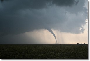
A wall cloud forms underneath the base of a cumulonimbus cloud,
and can be a hotbed for deadly tornadoes.
Wall clouds are formed by air flowing into the cumulonimbus clouds, which can
result in the wall cloud descending from the base of the cumulonimbus cloud, or
rising fractus clouds which join to the base of the storm cloud as the wall cloud
takes shape.
Wall clouds can be very large, and in the Northern Hemisphere they generally
form at the southern edge of cumulonimbus clouds.
Next Topic: Altocumulus Clouds
Weather Topic: What are Altostratus Clouds?
Home - Education - Cloud Types - Altostratus Clouds
 Next Topic: Cirrocumulus Clouds
Altostratus clouds form at mid to high-level altitudes
(between 2 and 7 km) and are created by a warm, stable air mass which causes
water vapor
to condense as it rise through the atmosphere. Usually altostratus clouds are
featureless sheets characterized by a uniform color.
In some cases, wind punching through the cloud formation may give it a waved
appearance, called altostratus undulatus. Altostratus clouds
are commonly seen with other cloud formations accompanying them.
Next Topic: Cirrocumulus Clouds
Current conditions powered by WeatherAPI.com


