Weather Alert in Illinois
Flood Warning issued April 3 at 12:14PM EDT by NWS Indianapolis IN
AREAS AFFECTED: Crawford, IL; Lawrence, IL; Knox, IN; Sullivan, IN
DESCRIPTION: ...The National Weather Service in Indianapolis IN has issued a Flood Warning for the following rivers in Indiana...Illinois... Wabash River at Riverton. .Multiple rounds of rainfall have brought lowland flooding to the Wabash River basin. The Wabash is expected to crest at Lafayette on Sunday, but the crest is not expected to reach the lower Wabash until the weekend of April 11th. The current river forecast includes expected rainfall amounts of 0.75 to 1.25 inches in the Wabash basin through Sunday morning, when dry weather is expected to move into the area. Variations from those expected amounts could change the crests as well as the amount of time spent in flood at any given location. * WHAT...Minor flooding is forecast. * WHERE...Wabash River at Riverton. * WHEN...From late tonight until further notice. * IMPACTS...At 18.5 feet, High water surrounds elevated river cabins. County roads to these cabins are impassable. Agricultural flooding is in progress. Seep water develops behind levees. * ADDITIONAL DETAILS... - At 11:00 AM EDT Friday /10:00 AM CDT Friday/ the stage was 11.7 feet. - Forecast...The river is expected to rise above flood stage late tonight and continue rising to a crest of 19.2 feet Friday, April 10. - Flood stage is 15.0 feet. - http://www.weather.gov/safety/flood
INSTRUCTION: Turn around, don't drown when encountering flooded roads. Most flood deaths occur in vehicles. Motorists should not attempt to drive around barricades or drive cars through flooded areas. Additional information is available at www.weather.gov/ind. The next statement should be issued this evening by around 1130 PM EDT /1030 PM CDT/.
Want more detail? Get the Complete 7 Day and Night Detailed Forecast!
Current U.S. National Radar--Current
The Current National Weather Radar is shown below with a UTC Time (subtract 5 hours from UTC to get Eastern Time).

National Weather Forecast--Current
The Current National Weather Forecast and National Weather Map are shown below.

National Weather Forecast for Tomorrow
Tomorrow National Weather Forecast and Tomorrow National Weather Map are show below.

North America Water Vapor (Moisture)
This map shows recent moisture content over North America. Bright and colored areas show high moisture (ie, clouds); brown indicates very little moisture present; black indicates no moisture.

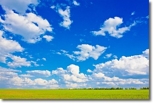
Weather Topic: What are Cumulus Clouds?
Home - Education - Cloud Types - Cumulus Clouds
 Next Topic: Drizzle
Cumulus clouds are fluffy and textured with rounded tops, and
may have flat bottoms. The border of a cumulus cloud
is clearly defined, and can have the appearance of cotton or cauliflower.
Cumulus clouds form at low altitudes (rarely above 2 km) but can grow very tall,
becoming cumulus congestus and possibly the even taller cumulonimbus clouds.
When cumulus clouds become taller, they have a greater chance of producing precipitation.
Next Topic: Drizzle
Weather Topic: What is Evaporation?
Home - Education - Precipitation - Evaporation
 Next Topic: Fog
Evaporation is the process which returns water from the earth
back to the atmosphere, and is another crucial process in the water cycle.
Evaporation is the transformation of liquid into gas, and it happens because
molecules are excited by the application of energy and turn into vapor.
In order for water to evaporate it has to be on the surface of a body of water.
Next Topic: Fog
Current conditions powered by WeatherAPI.com


