Weather Alert in Alaska
Winter Storm Warning issued February 19 at 10:59AM AKST until February 20 at 9:00AM AKST by NWS Juneau AK
AREAS AFFECTED: City and Borough of Sitka
DESCRIPTION: ...ACCUMULATING SNOW ACROSS THE PANHANDLE TO END THE WEEK... .A front moving across the gulf has begun to impact the panhandle with snow showers spreading along the outer coast and reaching southward to Petersburg and Wrangell as of 1045 am Thursday. The highest snow accumulations are still expected along the outer coast with orographic enhancement. A secondary batch of heavier showers will develop along the northern panhandle and progress southward as a deformation band associated with the surface low Thursday night into Friday. For inland areas, snow is expected to be light and fluffy in nature due to cold temperatures both aloft and down to the surface. Coastal communities will likely see wetter snow due to slightly warming surface temperatures through the day. * WHAT...Heavy snow. Additional snow accumulations of 6 to 10 inches. * WHERE...City and Borough of Sitka. * WHEN...Until 9 AM AKST Friday. * IMPACTS...Travel will be very difficult. The hazardous conditions could impact the morning and evening commute. * ADDITIONAL DETAILS...Snow showers have begun to impact the area and will do so throughout the day Thursday with variable intensity as an initial frontal band pushes into the outer coast. A secondary surge of heavier showers is expected to impact the area Thursday night as the surface low drops southward into the gulf.
INSTRUCTION: If you must travel, keep an extra flashlight, food, and water with you in case of an emergency. People are urged to prepare their property before the onset of winter weather. For the latest road conditions, where available, call 5 1 1 or visit 511.alaska.gov.
Want more detail? Get the Complete 7 Day and Night Detailed Forecast!
Current U.S. National Radar--Current
The Current National Weather Radar is shown below with a UTC Time (subtract 5 hours from UTC to get Eastern Time).

National Weather Forecast--Current
The Current National Weather Forecast and National Weather Map are shown below.

National Weather Forecast for Tomorrow
Tomorrow National Weather Forecast and Tomorrow National Weather Map are show below.

North America Water Vapor (Moisture)
This map shows recent moisture content over North America. Bright and colored areas show high moisture (ie, clouds); brown indicates very little moisture present; black indicates no moisture.

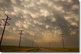
Weather Topic: What are Mammatus Clouds?
Home - Education - Cloud Types - Mammatus Clouds
 Next Topic: Nimbostratus Clouds
A mammatus cloud is a cloud with a unique feature which resembles
a web of pouches hanging along the base of the cloud.
In the United States, mammatus clouds tend to form in the warmer months, commonly
in the Midwest and eastern regions.
While they usually form at the bottom of a cumulonimbis cloud, they can also form
under altostratus, altocumulus, stratocumulus, and cirrus clouds. Mammatus clouds
warn that severe weather is close.
Next Topic: Nimbostratus Clouds
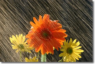
Weather Topic: What is Precipitation?
Home - Education - Precipitation - Precipitation
 Next Topic: Rain
Precipitation can refer to many different forms of water that
may fall from clouds. Precipitation occurs after a cloud has become saturated to
the point where its water particles are more dense than the air below the cloud.
In most cases, precipitation will reach the ground, but it is not uncommon for
precipitation to evaporate before it reaches the earth's surface.
When precipitation evaporates before it contacts the ground it is called Virga.
Graupel, hail, sleet, rain, drizzle, and snow are forms of precipitation, but fog
and mist are not considered precipitation because the water vapor which
constitutes them isn't dense enough to fall to the ground.
Next Topic: Rain
Current conditions powered by WeatherAPI.com


