Weather Alert in Alaska
Winter Weather Advisory issued February 19 at 10:59AM AKST until February 20 at 9:00AM AKST by NWS Juneau AK
AREAS AFFECTED: City and Borough of Juneau
DESCRIPTION: ...ACCUMULATING SNOW ACROSS THE PANHANDLE TO END THE WEEK... .A front moving across the gulf has begun to impact the panhandle with snow showers spreading along the outer coast and reaching southward to Petersburg and Wrangell as of 1045 am Thursday. The highest snow accumulations are still expected along the outer coast with orographic enhancement. A secondary batch of heavier showers will develop along the northern panhandle and progress southward as a deformation band associated with the surface low Thursday night into Friday. For inland areas, snow is expected to be light and fluffy in nature due to cold temperatures both aloft and down to the surface. Coastal communities will likely see wetter snow due to slightly warming surface temperatures through the day. * WHAT...Snow. Additional snow accumulations of 5 to 8 inches. * WHERE...City and Borough of Juneau. * WHEN...Until 9 AM AKST Friday. * IMPACTS...Travel could be difficult. The hazardous conditions could impact the evening and morning commute. * ADDITIONAL DETAILS...Snow showers have begun to impact the area and rates have picked up since early this morning, with almost 0.5 inches of snowfall at the forecast office as of 945 am. There is increasing confidence that heavier snow showers Thursday evening will last into Friday morning and impact the morning commute as the low dips southward into the gulf and a deformation band sets up.
INSTRUCTION: Slow down and use caution while traveling. People are urged to prepare their property before the onset of winter weather. For the latest road conditions, where available, call 5 1 1 or visit 511.alaska.gov.
Want more detail? Get the Complete 7 Day and Night Detailed Forecast!
Current U.S. National Radar--Current
The Current National Weather Radar is shown below with a UTC Time (subtract 5 hours from UTC to get Eastern Time).

National Weather Forecast--Current
The Current National Weather Forecast and National Weather Map are shown below.

National Weather Forecast for Tomorrow
Tomorrow National Weather Forecast and Tomorrow National Weather Map are show below.

North America Water Vapor (Moisture)
This map shows recent moisture content over North America. Bright and colored areas show high moisture (ie, clouds); brown indicates very little moisture present; black indicates no moisture.

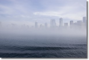
Weather Topic: What is Fog?
Home - Education - Cloud Types - Fog
 Next Topic: Fractus Clouds
Fog is technically a type of stratus cloud, which lies along the
ground and obscures visibility.
It is usually created when humidity in the air condenses into tiny water droplets.
Because of this, some places are more prone to foggy weather, such as regions
close to a body of water.
Fog is similar to mist; both are the appearance of water droplets suspended in
the air, but fog is the term applied to the condition when visibility is less than 1 km.
Next Topic: Fractus Clouds
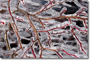
Weather Topic: What is Freezing Rain?
Home - Education - Precipitation - Freezing Rain
 Next Topic: Graupel
Freezing rain is a condition where precipitation which has fallen in the form of
water droplets reaches temperatures which are below freezing and freezes upon
coming into contact
with surface objects. The result of this precipitation is a glaze of ice which
can be damaging to plants and man-made structures. A severe onset of freezing
rain which results in a very thick glaze of ice is known as an ice storm.
Next Topic: Graupel
Current conditions powered by WeatherAPI.com


