Weather Alert in Alaska
Flood Watch issued August 27 at 11:46AM AKDT until August 29 at 12:00PM AKDT by NWS Fairbanks AK
AREAS AFFECTED: South Slopes of the Western Brooks Range; Upper Kobuk Valleys
DESCRIPTION: Heavy rainfall that caused rapid rises in headwater streams will continue to cause water level rises on main stem rivers through the end of the week. The Koyukuk River is expected to crest at Allakaket overnight on Wednesday, timing of the Alatna River crest at the confluence with the Koyukuk may be coincident. The Kobuk River is cresting at Kobuk today and may stay high or have another rise through the end of the week due to continued rainfall. * WHAT...Flooding caused by excessive rainfall continues to be possible. * WHERE...Including the following areas, South Slopes of the Western Brooks Range and Upper Kobuk Valleys. This includes the cities of Walker Lake, Ambler, Shungnak, And Kobuk. * WHEN...Through Friday morning. * IMPACTS...Excessive runoff may result in flooding of rivers, creeks, streams, and other low-lying and flood-prone locations. Area creeks and streams are running high and could flood with more heavy rain. Flooding may occur in poor drainage areas. * ADDITIONAL DETAILS... - Moderate rainfall will continue in the Southern Brooks Range on areas already saturated by heavy rainfall this week. - Http://www.weather.gov/aprfc
INSTRUCTION: Persons living along streams should stay alert and be prepared to take action if a warning or advisory is issued, or flooding is observed. You should monitor later forecasts and be alert for possible Flood Warnings. Those living in areas prone to flooding should be prepared to take action should flooding develop. Stay tuned to further developments by listening to your local radio, television, or NOAA Weather Radio for further information.
Want more detail? Get the Complete 7 Day and Night Detailed Forecast!
Current U.S. National Radar--Current
The Current National Weather Radar is shown below with a UTC Time (subtract 5 hours from UTC to get Eastern Time).

National Weather Forecast--Current
The Current National Weather Forecast and National Weather Map are shown below.

National Weather Forecast for Tomorrow
Tomorrow National Weather Forecast and Tomorrow National Weather Map are show below.

North America Water Vapor (Moisture)
This map shows recent moisture content over North America. Bright and colored areas show high moisture (ie, clouds); brown indicates very little moisture present; black indicates no moisture.

Weather Topic: What are Wall Clouds?
Home - Education - Cloud Types - Wall Clouds
 Next Topic: Altocumulus Clouds
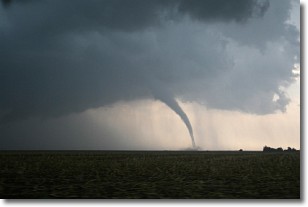
A wall cloud forms underneath the base of a cumulonimbus cloud,
and can be a hotbed for deadly tornadoes.
Wall clouds are formed by air flowing into the cumulonimbus clouds, which can
result in the wall cloud descending from the base of the cumulonimbus cloud, or
rising fractus clouds which join to the base of the storm cloud as the wall cloud
takes shape.
Wall clouds can be very large, and in the Northern Hemisphere they generally
form at the southern edge of cumulonimbus clouds.
Next Topic: Altocumulus Clouds
Weather Topic: What are Altostratus Clouds?
Home - Education - Cloud Types - Altostratus Clouds
 Next Topic: Cirrocumulus Clouds
Altostratus clouds form at mid to high-level altitudes
(between 2 and 7 km) and are created by a warm, stable air mass which causes
water vapor
to condense as it rise through the atmosphere. Usually altostratus clouds are
featureless sheets characterized by a uniform color.
In some cases, wind punching through the cloud formation may give it a waved
appearance, called altostratus undulatus. Altostratus clouds
are commonly seen with other cloud formations accompanying them.
Next Topic: Cirrocumulus Clouds
Current conditions powered by WeatherAPI.com


