Weather Alert in Texas
Flash Flood Warning issued May 6 at 4:24AM CDT until May 6 at 7:30AM CDT by NWS San Angelo TX
AREAS AFFECTED: Tom Green, TX
DESCRIPTION: FFWSJT The National Weather Service in San Angelo has issued a * Flash Flood Warning for... Northeastern Tom Green County in west central Texas... * Until 730 AM CDT. * At 422 AM CDT, Doppler radar indicated thunderstorms producing heavy rain across the warned area, including San Angelo. Between 1 and 2 inches of rain have fallen in San Angelo. Additional rainfall amounts up to 1.5 inches are possible in the warned area, as a second line of thunderstorms moves east across the city between 5 and 6 AM. Flash flooding is ongoing or expected to begin shortly. HAZARD...Flash flooding caused by thunderstorms. SOURCE...Radar. IMPACT...Flash flooding of small creeks and streams, urban areas, highways, streets and underpasses as well as other poor drainage and low-lying areas. * Some locations that will experience flash flooding include... San Angelo, O.C. Fisher Reservoir, Goodfellow Air Force Base, San Angelo State Park, Lake Nasworthy, Grape Creek, Carlsbad and Harriet. This includes the following Low Water Crossings... Howard and Webster, College Hills and Millbrook, Jackson From Knickerbocker to South Bryant, Southwest Blvd and Loop 306, 300 block of North Archer, 1500 Block of Spaulding, Parkwood and Lindenwood, Sul Ross At Red Arroyo Crossing, Huntington and Sunset and Huntington and Sunset.
INSTRUCTION: Turn around, don't drown when encountering flooded roads. Most flood deaths occur in vehicles. Be especially cautious at night when it is harder to recognize the dangers of flooding.
Want more detail? Get the Complete 7 Day and Night Detailed Forecast!
Current U.S. National Radar--Current
The Current National Weather Radar is shown below with a UTC Time (subtract 5 hours from UTC to get Eastern Time).

National Weather Forecast--Current
The Current National Weather Forecast and National Weather Map are shown below.

National Weather Forecast for Tomorrow
Tomorrow National Weather Forecast and Tomorrow National Weather Map are show below.

North America Water Vapor (Moisture)
This map shows recent moisture content over North America. Bright and colored areas show high moisture (ie, clouds); brown indicates very little moisture present; black indicates no moisture.

Weather Topic: What are Stratocumulus Clouds?
Home - Education - Cloud Types - Stratocumulus Clouds
 Next Topic: Stratus Clouds
Stratocumulus clouds are similar to altocumulus clouds in their
fluffy appearance, but have a slightly darker shade due to their additional mass.
A good way to distinguish the two cloud types is to hold your hand out and measure
the size of an individual cloud; if it is the size of your thumb it is generally
an altocumulus cloud, if it is the size of your hand it is generally a
stratocumulus cloud.
It is uncommon for stratocumulus clouds to produce precipitation, but if they do
it is usually a light rain or snow.
Next Topic: Stratus Clouds
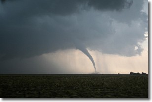
Weather Topic: What are Wall Clouds?
Home - Education - Cloud Types - Wall Clouds
 Next Topic: Altocumulus Clouds
A wall cloud forms underneath the base of a cumulonimbus cloud,
and can be a hotbed for deadly tornadoes.
Wall clouds are formed by air flowing into the cumulonimbus clouds, which can
result in the wall cloud descending from the base of the cumulonimbus cloud, or
rising fractus clouds which join to the base of the storm cloud as the wall cloud
takes shape.
Wall clouds can be very large, and in the Northern Hemisphere they generally
form at the southern edge of cumulonimbus clouds.
Next Topic: Altocumulus Clouds
Current conditions powered by WeatherAPI.com


