Weather Alert in Ohio
Winter Weather Advisory issued February 5 at 9:57PM EST until February 7 at 1:00AM EST by NWS Cleveland OH
AREAS AFFECTED: Cuyahoga; Geauga
DESCRIPTION: * WHAT...Snow expected. Total snow accumulations between 2 and 5 inches. Winds gusting as high as 40 mph may will produce patchy to areas of blowing snow Friday evening. * WHERE...Cuyahoga and Geauga Counties. * WHEN...From 7 AM Friday to 1 AM EST Saturday. * IMPACTS...Plan on slippery road conditions with slower travel likely. The hazardous conditions could impact the Friday morning and evening commutes. Blowing snow may reduce visibility less than a mile at times. * ADDITIONAL DETAILS...A broken line of snow squalls or heavier burst of snow may develop along an Arctic front as it pushes through the area Friday evening.
INSTRUCTION: Slow down and use caution while traveling. The Ohio Department of Transportation and Ohio Turnpike and Infrastructure Commission strongly encourage motorists to heed all travel restrictions and delay unnecessary travel. Visit www.ohgo.com for the latest travel, roadway, and traffic conditions.
Want more detail? Get the Complete 7 Day and Night Detailed Forecast!
Current U.S. National Radar--Current
The Current National Weather Radar is shown below with a UTC Time (subtract 5 hours from UTC to get Eastern Time).

National Weather Forecast--Current
The Current National Weather Forecast and National Weather Map are shown below.

National Weather Forecast for Tomorrow
Tomorrow National Weather Forecast and Tomorrow National Weather Map are show below.

North America Water Vapor (Moisture)
This map shows recent moisture content over North America. Bright and colored areas show high moisture (ie, clouds); brown indicates very little moisture present; black indicates no moisture.

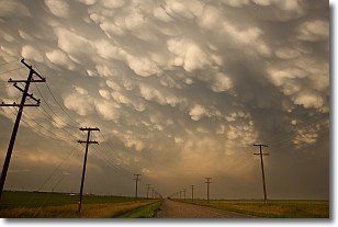
Weather Topic: What are Mammatus Clouds?
Home - Education - Cloud Types - Mammatus Clouds
 Next Topic: Nimbostratus Clouds
A mammatus cloud is a cloud with a unique feature which resembles
a web of pouches hanging along the base of the cloud.
In the United States, mammatus clouds tend to form in the warmer months, commonly
in the Midwest and eastern regions.
While they usually form at the bottom of a cumulonimbis cloud, they can also form
under altostratus, altocumulus, stratocumulus, and cirrus clouds. Mammatus clouds
warn that severe weather is close.
Next Topic: Nimbostratus Clouds
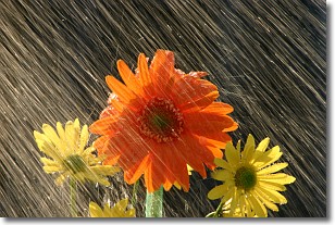
Weather Topic: What is Precipitation?
Home - Education - Precipitation - Precipitation
 Next Topic: Rain
Precipitation can refer to many different forms of water that
may fall from clouds. Precipitation occurs after a cloud has become saturated to
the point where its water particles are more dense than the air below the cloud.
In most cases, precipitation will reach the ground, but it is not uncommon for
precipitation to evaporate before it reaches the earth's surface.
When precipitation evaporates before it contacts the ground it is called Virga.
Graupel, hail, sleet, rain, drizzle, and snow are forms of precipitation, but fog
and mist are not considered precipitation because the water vapor which
constitutes them isn't dense enough to fall to the ground.
Next Topic: Rain
Current conditions powered by WeatherAPI.com


