Weather Alert in New York
Winter Storm Warning issued February 20 at 1:28PM EST until February 21 at 10:00AM EST by NWS Burlington VT
AREAS AFFECTED: Northern St. Lawrence; Eastern Clinton; Southern Franklin; Western Clinton; Western Essex; Eastern Essex; Grand Isle; Washington; Orange; Eastern Addison; Eastern Rutland; Western Windsor; Eastern Windsor
DESCRIPTION: * WHAT...Heavy snow. Total snow accumulations between 5 and 10 inches. * WHERE...Portions of northern New York and central, northwest, and southern Vermont. * WHEN...Until 10 AM EST Saturday. * IMPACTS...Travel could be very difficult. The hazardous conditions will impact this evening's commute. * ADDITIONAL DETAILS...Snowfall rates of 1 to 2 inches per hour are likely, especially between 4 and 8 PM. Snow will be initially wet and become increasingly dry tonight into Saturday. Isolated power outages could occur due to the weight of the snow.
INSTRUCTION: If you must travel, keep an extra flashlight, food, and water in your vehicle in case of an emergency. For the latest on road conditions in Vermont, visit https://newengland511.org and for New York, visit https://511ny.org.
Want more detail? Get the Complete 7 Day and Night Detailed Forecast!
Current U.S. National Radar--Current
The Current National Weather Radar is shown below with a UTC Time (subtract 5 hours from UTC to get Eastern Time).

National Weather Forecast--Current
The Current National Weather Forecast and National Weather Map are shown below.

National Weather Forecast for Tomorrow
Tomorrow National Weather Forecast and Tomorrow National Weather Map are show below.

North America Water Vapor (Moisture)
This map shows recent moisture content over North America. Bright and colored areas show high moisture (ie, clouds); brown indicates very little moisture present; black indicates no moisture.

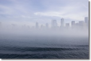
Weather Topic: What is Fog?
Home - Education - Cloud Types - Fog
 Next Topic: Fractus Clouds
Fog is technically a type of stratus cloud, which lies along the
ground and obscures visibility.
It is usually created when humidity in the air condenses into tiny water droplets.
Because of this, some places are more prone to foggy weather, such as regions
close to a body of water.
Fog is similar to mist; both are the appearance of water droplets suspended in
the air, but fog is the term applied to the condition when visibility is less than 1 km.
Next Topic: Fractus Clouds
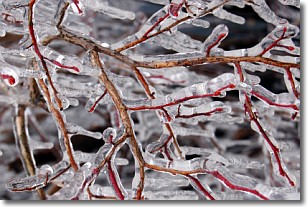
Weather Topic: What is Freezing Rain?
Home - Education - Precipitation - Freezing Rain
 Next Topic: Graupel
Freezing rain is a condition where precipitation which has fallen in the form of
water droplets reaches temperatures which are below freezing and freezes upon
coming into contact
with surface objects. The result of this precipitation is a glaze of ice which
can be damaging to plants and man-made structures. A severe onset of freezing
rain which results in a very thick glaze of ice is known as an ice storm.
Next Topic: Graupel
Current conditions powered by WeatherAPI.com


