Weather Alert in South Carolina
Flood Warning issued September 7 at 6:32PM EDT until September 7 at 10:00PM EDT by NWS Charleston SC
AREAS AFFECTED: Charleston, SC
DESCRIPTION: * WHAT...Flooding caused by excessive rainfall is expected. * WHERE...A portion of southeast South Carolina, including the following county, Charleston. * WHEN...Until 1000 PM EDT. * IMPACTS...Numerous roads remain closed due to flooding. Expect many areas of slow moving or standing water. It will take several hours for all the water from these storms to work through local drainage systems in urban areas. * ADDITIONAL DETAILS... - At 625 PM EDT, emergency management officials continued to report road closures across much of the Downtown Charleston area from earlier flooding rains. Drainage of flood waters will become increasingly hampered as high tide approaches in the Charleston Harbor, which will occur shortly after 830 PM. Tide levels are expected to peak in the 7.0 to 7.2 ft mean lower low water range which, in itself, would typically produce salt water flooding in parts of Downtown Charleston. The combination of ongoing fresh water flooding and increasing saltwater flooding will likely produce additional road closures and other impacts across the Downtown area. - Some locations that will experience flooding include... Downtown Charleston, Marion Square, Medical University Of South Carolina, Columbus Street Terminal and The Citadel. - This includes I-26 near mile marker 221.
INSTRUCTION: Turn around, don't drown when encountering flooded roads. Most flood deaths occur in vehicles. Be especially cautious at night when it is harder to recognize the dangers of flooding.
Want more detail? Get the Complete 7 Day and Night Detailed Forecast!
Current U.S. National Radar--Current
The Current National Weather Radar is shown below with a UTC Time (subtract 5 hours from UTC to get Eastern Time).

National Weather Forecast--Current
The Current National Weather Forecast and National Weather Map are shown below.

National Weather Forecast for Tomorrow
Tomorrow National Weather Forecast and Tomorrow National Weather Map are show below.

North America Water Vapor (Moisture)
This map shows recent moisture content over North America. Bright and colored areas show high moisture (ie, clouds); brown indicates very little moisture present; black indicates no moisture.

Weather Topic: What is Hail?
Home - Education - Precipitation - Hail
 Next Topic: Hole Punch Clouds
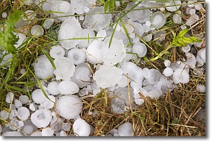
Hail is a form of precipitation which is recognized by large solid balls or
clumps of ice. Hail is created by thunderstorm clouds with strong updrafts of wind.
As the hailstones remain in the updraft, ice is deposited onto them until their
weight becomes heavy enough for them to fall to the earth's surface.
Hail storms can cause significant damage to crops, aircrafts, and man-made structures,
despite the fact that the duration is usually less than ten minutes.
Next Topic: Hole Punch Clouds
Weather Topic: What are Mammatus Clouds?
Home - Education - Cloud Types - Mammatus Clouds
 Next Topic: Nimbostratus Clouds
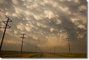
A mammatus cloud is a cloud with a unique feature which resembles
a web of pouches hanging along the base of the cloud.
In the United States, mammatus clouds tend to form in the warmer months, commonly
in the Midwest and eastern regions.
While they usually form at the bottom of a cumulonimbis cloud, they can also form
under altostratus, altocumulus, stratocumulus, and cirrus clouds. Mammatus clouds
warn that severe weather is close.
Next Topic: Nimbostratus Clouds
Current conditions powered by WeatherAPI.com


