Weather Alert in New York
Winter Storm Watch issued February 19 at 1:21AM EST until February 21 at 10:00AM EST by NWS Burlington VT
AREAS AFFECTED: Eastern Clinton; Western Clinton; Western Essex; Eastern Essex; Eastern Addison; Eastern Rutland; Western Windsor
DESCRIPTION: * WHAT...Heavy snow possible. Total snow accumulations between 4 and 9 inches possible. * WHERE...Portions of northern New York and central and southern Vermont. * WHEN...From Friday morning through Saturday morning. * IMPACTS...Travel could be very difficult. The hazardous conditions could impact the Friday evening commute. * ADDITIONAL DETAILS...Snow will be initially wet, and the potential exists for 1 inch per hour snowfall rates Friday evening. Snow will trend lighter and become increasingly dry. Isolated power outages could occur before snow characteristics trend drier.
INSTRUCTION: Monitor the latest forecasts for updates on this situation.
Want more detail? Get the Complete 7 Day and Night Detailed Forecast!
Current U.S. National Radar--Current
The Current National Weather Radar is shown below with a UTC Time (subtract 5 hours from UTC to get Eastern Time).

National Weather Forecast--Current
The Current National Weather Forecast and National Weather Map are shown below.

National Weather Forecast for Tomorrow
Tomorrow National Weather Forecast and Tomorrow National Weather Map are show below.

North America Water Vapor (Moisture)
This map shows recent moisture content over North America. Bright and colored areas show high moisture (ie, clouds); brown indicates very little moisture present; black indicates no moisture.

Weather Topic: What is Graupel?
Home - Education - Precipitation - Graupel
 Next Topic: Hail
Graupel is a form of precipitation that is created by atmospheric conditions
which cause supercooled water droplets to contact snow crystals and freeze to
their surface.
Sometimes known as soft hail or snow pellets, graupel is delicate and easily
destroyed by touch. Whereas hail usually falls during severe weather, graupel
doesn't require such conditions to form, and can form in mild precipitation
similar to situations which produce snowfall.
Next Topic: Hail
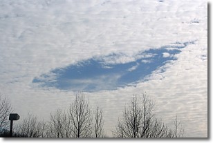
Weather Topic: What are Hole Punch Clouds?
Home - Education - Cloud Types - Hole Punch Clouds
 Next Topic: Mammatus Clouds
A hole punch cloud is an unusual occurrence when a disk-shaped
hole appears in a cirrostratus, cirrocumulus, or altocumulus cloud.
When part of the cloud forms ice crystals, water droplets in the surrounding area
of the cloud evaporate. The effect of this process produces a large elliptical
gap in the cloud. The hole punch cloud formation is rare, but it is not specific
to any geographic area.
Other names which have been used to describe this phenomena include fallstreak hole,
skypunch, and cloud hole.
Next Topic: Mammatus Clouds
Current conditions powered by WeatherAPI.com


