Weather Alert in Iowa
Winter Storm Warning issued February 19 at 3:15PM CST until February 20 at 9:00AM CST by NWS La Crosse WI
AREAS AFFECTED: Allamakee; Fayette; Clayton; Crawford; Richland; Grant
DESCRIPTION: ...BAND OF MODERATE TO HEAVY SNOW EXPECTED TONIGHT... .A band of snow develops across northeast Iowa into southwest Wisconsin this evening and lasts through the overnight, departing between sunrise and mid-morning. The snow will be heavy at times with rates exceeding 1" per hour, quickly leading to snow-covered and slippery roads. The heaviest snow is forecast to fall in a relatively narrow band with amounts quickly decreasing on either side of the band. Any small changes to the placement of the snow band could change forecast snow amounts at a given location very quickly. Confidence in heavy amounts is highest in far southwest Wisconsin into Juneau and Adams Counties and adjacent areas of northeast Iowa. Areas to the northwest from Charles City to Tomah may see a few inches of accumulation, but amounts will drop off quickly in some cases within a few miles. * WHAT...Heavy snow expected. Total snow accumulations between 4 and 6 inches. Winds gusting as high as 40 mph. * WHERE...In northeast Iowa, Fayette, Allamakee, and Clayton Counties. In southwest Wisconsin, Crawford, Richland, and Grant Counties. * WHEN...From 8 PM this evening to 9 AM CST Friday. * IMPACTS...Travel could be very difficult. The hazardous conditions could impact the Friday morning commute.
INSTRUCTION: If you must travel, keep an extra flashlight, food, and water in your vehicle in case of an emergency. In Iowa, visit 511ia.org for road conditions. In Wisconsin, visit 511wi.gov for road conditions.
Want more detail? Get the Complete 7 Day and Night Detailed Forecast!
Current U.S. National Radar--Current
The Current National Weather Radar is shown below with a UTC Time (subtract 5 hours from UTC to get Eastern Time).

National Weather Forecast--Current
The Current National Weather Forecast and National Weather Map are shown below.

National Weather Forecast for Tomorrow
Tomorrow National Weather Forecast and Tomorrow National Weather Map are show below.

North America Water Vapor (Moisture)
This map shows recent moisture content over North America. Bright and colored areas show high moisture (ie, clouds); brown indicates very little moisture present; black indicates no moisture.

Weather Topic: What is Snow?
Home - Education - Precipitation - Snow
 Next Topic: Stratocumulus Clouds
Snow is precipitation taking the form of ice crystals. Each ice crystal, or snowflake,
has unique characteristics, but all of them grow in a hexagonal structure.
Snowfall can last for sustained periods of time and result in significant buildup
of snow on the ground.
On the earth's surface, snow starts out light and powdery, but as it begins to melt
it tends to become more granular, producing small bits of ice which have the consistency of
sand. After several cycles of melting and freezing, snow can become very dense
and ice-like, commonly known as snow pack.
Next Topic: Stratocumulus Clouds
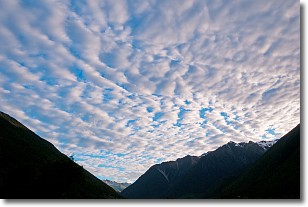
Weather Topic: What are Stratus Clouds?
Home - Education - Cloud Types - Stratus Clouds
 Next Topic: Wall Clouds
Stratus clouds are similar to altostratus clouds, but form at a
lower altitude and are identified by their fog-like appearance, lacking the
distinguishing features of most clouds.
Stratus clouds are wider than most clouds, and their base has a smooth, uniform
look which is lighter in color than a nimbostratus cloud.
The presence of a stratus cloud indicates the possibility of minor precipitation,
such as drizzle, but heavier precipitation does not typically arrive in the form
of a stratus cloud.
Next Topic: Wall Clouds
Current conditions powered by WeatherAPI.com


