Weather Alert in Oregon
Special Weather Statement issued February 5 at 12:28PM PST by NWS Pendleton OR
AREAS AFFECTED: Northern Blue Mountains of Oregon; Foothills of the Northern Blue Mountains of Oregon; Foothills of the Southern Blue Mountains of Oregon; North Central Oregon; Central Oregon; Lower Columbia Basin of Washington; Foothills of the Blue Mountains of Washington
DESCRIPTION: Areas of dense fog reducing visibility as low as one quarter mile will persist across many areas especially above about 2000 ft through the duration of the afternoon and into the evening. By the evening and overnight, many of these areas of dense fog will expand to lower elevations, becoming more widespread, especially for areas along the foothills of the Blue Mountains. Motorists should be prepared for dense fog expanding overnight, potentially creating a travel hazard well into the late morning on Friday.
INSTRUCTION: N/A
Want more detail? Get the Complete 7 Day and Night Detailed Forecast!
Current U.S. National Radar--Current
The Current National Weather Radar is shown below with a UTC Time (subtract 5 hours from UTC to get Eastern Time).

National Weather Forecast--Current
The Current National Weather Forecast and National Weather Map are shown below.

National Weather Forecast for Tomorrow
Tomorrow National Weather Forecast and Tomorrow National Weather Map are show below.

North America Water Vapor (Moisture)
This map shows recent moisture content over North America. Bright and colored areas show high moisture (ie, clouds); brown indicates very little moisture present; black indicates no moisture.

Weather Topic: What is Graupel?
Home - Education - Precipitation - Graupel
 Next Topic: Hail
Graupel is a form of precipitation that is created by atmospheric conditions
which cause supercooled water droplets to contact snow crystals and freeze to
their surface.
Sometimes known as soft hail or snow pellets, graupel is delicate and easily
destroyed by touch. Whereas hail usually falls during severe weather, graupel
doesn't require such conditions to form, and can form in mild precipitation
similar to situations which produce snowfall.
Next Topic: Hail
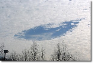
Weather Topic: What are Hole Punch Clouds?
Home - Education - Cloud Types - Hole Punch Clouds
 Next Topic: Mammatus Clouds
A hole punch cloud is an unusual occurrence when a disk-shaped
hole appears in a cirrostratus, cirrocumulus, or altocumulus cloud.
When part of the cloud forms ice crystals, water droplets in the surrounding area
of the cloud evaporate. The effect of this process produces a large elliptical
gap in the cloud. The hole punch cloud formation is rare, but it is not specific
to any geographic area.
Other names which have been used to describe this phenomena include fallstreak hole,
skypunch, and cloud hole.
Next Topic: Mammatus Clouds
Current conditions powered by WeatherAPI.com


