Weather Alert in Illinois
Hydrologic Outlook issued March 9 at 1:57PM CDT by NWS Chicago IL
AREAS AFFECTED: Cook, IL; De Kalb, IL; DuPage, IL; Ford, IL; Grundy, IL; Iroquois, IL; Kane, IL; Kankakee, IL; Kendall, IL; La Salle, IL; Lee, IL; Livingston, IL; Will, IL; Benton, IN; Jasper, IN; Lake, IN; Newton, IN; Porter, IN
DESCRIPTION: ESFLOT Waves of showers and thunderstorms are likely late Tuesday into Wednesday. Some storms may produce rainfall rates in excess of 1 to 2 inches per hour, which could lead to localized flooding. The locations with the highest risk of flooding are somewhat uncertain. The highest probability of heavy rainfall is generally along and south of I-80, but drought conditions worsen toward Livingston, Ford, Iroquois, and Benton counties. Drought conditions increase the rainfall rates needed to cause flood impact. Closer to the Chicago Metropolitan Area, lower rainfall rates would be required to cause flood impacts, but the probability of heavy rainfall there is lower. This outlook means that elevated water levels and potential impacts are possible, but not yet certain. Persons should closely monitor forecasts including the possibility of flood watches, warnings, and advisories. This product will be updated by tomorrow morning.
INSTRUCTION: N/A
Want more detail? Get the Complete 7 Day and Night Detailed Forecast!
Current U.S. National Radar--Current
The Current National Weather Radar is shown below with a UTC Time (subtract 5 hours from UTC to get Eastern Time).

National Weather Forecast--Current
The Current National Weather Forecast and National Weather Map are shown below.

National Weather Forecast for Tomorrow
Tomorrow National Weather Forecast and Tomorrow National Weather Map are show below.

North America Water Vapor (Moisture)
This map shows recent moisture content over North America. Bright and colored areas show high moisture (ie, clouds); brown indicates very little moisture present; black indicates no moisture.

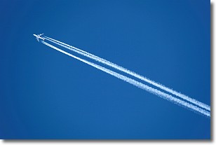
Weather Topic: What are Contrails?
Home - Education - Cloud Types - Contrails
 Next Topic: Cumulonimbus Clouds
A contrail is an artificial cloud, created by the passing of an
aircraft.
Contrails form because water vapor in the exhaust of aircraft engines is suspended
in the air under certain temperatures and humidity conditions. These contrails
are called exhaust contrails.
Another type of contrail can form due to a temporary reduction in air pressure
moving over the plane's surface, causing condensation.
These are called aerodynamic contrails.
When you can see your breath on a cold day, it is also because of condensation.
The reason contrails last longer than the condensation from your breath is
because the water in contrails freezes into ice particles.
Next Topic: Cumulonimbus Clouds
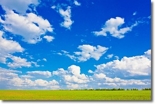
Weather Topic: What are Cumulus Clouds?
Home - Education - Cloud Types - Cumulus Clouds
 Next Topic: Drizzle
Cumulus clouds are fluffy and textured with rounded tops, and
may have flat bottoms. The border of a cumulus cloud
is clearly defined, and can have the appearance of cotton or cauliflower.
Cumulus clouds form at low altitudes (rarely above 2 km) but can grow very tall,
becoming cumulus congestus and possibly the even taller cumulonimbus clouds.
When cumulus clouds become taller, they have a greater chance of producing precipitation.
Next Topic: Drizzle
Current conditions powered by WeatherAPI.com


