Weather Alert in New York
Winter Storm Warning issued February 22 at 12:28PM EST until February 23 at 7:00PM EST by NWS Albany NY
AREAS AFFECTED: Schoharie; Western Schenectady; Eastern Schenectady; Western Albany; Eastern Albany; Western Rensselaer; Eastern Rensselaer; Bennington; Western Windham; Eastern Windham
DESCRIPTION: * WHAT...Heavy snow expected. Total snow accumulations between 4 and 10 inches across Schoharie County, the Helderbergs, Capital Region and northern Taconics of eastern New York and 6 to 12 inches across southern Vermont. Winds gusting as high as 40 mph. * WHERE...Schoharie, Schenectady, Albany and Rensselaer Counties in eastern New York and Bennington and Windham Counties in southern Vermont. * WHEN...From 7 PM this evening to 7 PM EST Monday. * IMPACTS...Travel could be difficult. Visibility will be reduced late tonight into Monday morning due to falling and blowing snow. The hazardous conditions could impact the Monday morning commute and possibly the evening commute as well for eastern areas. * ADDITIONAL DETAILS...A powerful nor'easter will impact the region this evening through Monday. There will be a sharp gradient of snowfall totals and the higher snowfall amounts will be favored across the higher elevations and southern parts of the area. Snowfall rates could approach one inch per hour within bands late tonight into Monday morning.
INSTRUCTION: If you must travel, keep an extra flashlight, food, and water in your vehicle in case of an emergency.
Want more detail? Get the Complete 7 Day and Night Detailed Forecast!
Current U.S. National Radar--Current
The Current National Weather Radar is shown below with a UTC Time (subtract 5 hours from UTC to get Eastern Time).

National Weather Forecast--Current
The Current National Weather Forecast and National Weather Map are shown below.

National Weather Forecast for Tomorrow
Tomorrow National Weather Forecast and Tomorrow National Weather Map are show below.

North America Water Vapor (Moisture)
This map shows recent moisture content over North America. Bright and colored areas show high moisture (ie, clouds); brown indicates very little moisture present; black indicates no moisture.

Weather Topic: What are Stratus Clouds?
Home - Education - Cloud Types - Stratus Clouds
 Next Topic: Wall Clouds
Stratus clouds are similar to altostratus clouds, but form at a
lower altitude and are identified by their fog-like appearance, lacking the
distinguishing features of most clouds.
Stratus clouds are wider than most clouds, and their base has a smooth, uniform
look which is lighter in color than a nimbostratus cloud.
The presence of a stratus cloud indicates the possibility of minor precipitation,
such as drizzle, but heavier precipitation does not typically arrive in the form
of a stratus cloud.
Next Topic: Wall Clouds
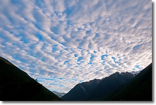
Weather Topic: What are Altocumulus Clouds?
Home - Education - Cloud Types - Altocumulus Clouds
 Next Topic: Altostratus Clouds
Similar to cirrocumulus clouds, altocumulus clouds are
characterized by cloud patches. They are distinguished by larger cloudlets
than cirrocumulus clouds but are still smaller than stratocumulus clouds.
Altocumulus clouds most commonly form in middle altitudes (between 2 and 5 km)
and may resemble, at times, the shape of a flying saucer.
These uncommon formations, called altocumulus lenticularis, are created by uplift
in the atmosphere and are most often seen in close proximity to mountains.
Next Topic: Altostratus Clouds
Current conditions powered by WeatherAPI.com


