Weather Alert in Montana
Avalanche Warning issued February 24 at 6:14AM MST by NWS Missoula MT
AREAS AFFECTED: Kootenai/Cabinet Region; West Glacier Region
DESCRIPTION: AVWMSO The following message is transmitted at the request of Flathead Avalanche Center Hungry Horse MT. ...AVALANCHE WARNING ISSUED BY THE FLATHEAD AVALANCHE CENTER... 06:00 MST Tue Feb 24 2026 The Flathead Avalanche Center in Hungry Horse has issued a BACKCOUNTRY AVALANCHE WARNING for the following areas: NWS Missoula MT - MTZ001 (MTZ001)...MTZ002 (MTZ002) * WHAT...New and wind-drifted snow have created very dangerous avalanche conditions. * WHERE...Slopes above 5000 feet in the Flathead Range and the Lake McDonald and Marias Pass areas of Glacier National Park. Slopes above 6500 feet in the Swan and Whitefish Ranges. * WHEN...In effect from Tue 06:00 MST to Wed 06:00 MST. * IMPACTS...Natural and human-triggered avalanches are very likely. Avalanches will release on weak layers buried two to four feet deep. These will run long distances, travel into low-angle terrain, and can cover snowmobile and snowshoeing trails and backcountry ski routes. Avalanches may connect across terrain features like ridges, releasing multiple start zones at once. Avalanches can be triggered from long distances away. Smaller slopes, such as roadcuts, may also avalanche, depositing a surprising amount of debris on roads below. * PRECAUTIONARY / PREPAREDNESS ACTIONS...Very dangerous avalanche conditions. Pay close attention to the terrain around you. Avoid traveling on and under steep slopes. Consult http://www.flatheadavalanche.org/ or www.avalanche.org for more detailed information. Similar avalanche danger may exist at locations outside the coverage area of this or any avalanche center.
INSTRUCTION: N/A
Want more detail? Get the Complete 7 Day and Night Detailed Forecast!
Current U.S. National Radar--Current
The Current National Weather Radar is shown below with a UTC Time (subtract 5 hours from UTC to get Eastern Time).

National Weather Forecast--Current
The Current National Weather Forecast and National Weather Map are shown below.

National Weather Forecast for Tomorrow
Tomorrow National Weather Forecast and Tomorrow National Weather Map are show below.

North America Water Vapor (Moisture)
This map shows recent moisture content over North America. Bright and colored areas show high moisture (ie, clouds); brown indicates very little moisture present; black indicates no moisture.

Weather Topic: What are Stratocumulus Clouds?
Home - Education - Cloud Types - Stratocumulus Clouds
 Next Topic: Stratus Clouds
Stratocumulus clouds are similar to altocumulus clouds in their
fluffy appearance, but have a slightly darker shade due to their additional mass.
A good way to distinguish the two cloud types is to hold your hand out and measure
the size of an individual cloud; if it is the size of your thumb it is generally
an altocumulus cloud, if it is the size of your hand it is generally a
stratocumulus cloud.
It is uncommon for stratocumulus clouds to produce precipitation, but if they do
it is usually a light rain or snow.
Next Topic: Stratus Clouds
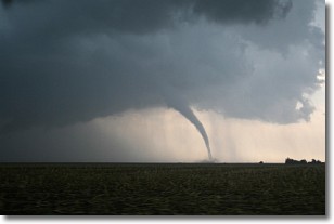
Weather Topic: What are Wall Clouds?
Home - Education - Cloud Types - Wall Clouds
 Next Topic: Altocumulus Clouds
A wall cloud forms underneath the base of a cumulonimbus cloud,
and can be a hotbed for deadly tornadoes.
Wall clouds are formed by air flowing into the cumulonimbus clouds, which can
result in the wall cloud descending from the base of the cumulonimbus cloud, or
rising fractus clouds which join to the base of the storm cloud as the wall cloud
takes shape.
Wall clouds can be very large, and in the Northern Hemisphere they generally
form at the southern edge of cumulonimbus clouds.
Next Topic: Altocumulus Clouds
Current conditions powered by WeatherAPI.com


