Weather Alert in Pennsylvania
Winter Weather Advisory issued February 24 at 3:24AM EST until February 25 at 1:00PM EST by NWS Cleveland OH
AREAS AFFECTED: Southern Erie; Crawford
DESCRIPTION: * WHAT...For the first Winter Weather Advisory, lake enhanced snow. Additional snow accumulations of 1 to 2 inches, especially in the higher elevations southeast of Interstate 90. For the second Winter Weather Advisory, snow expected. Total snow accumulations between 2 and 5 inches, primarily south of Interstate 90 and east of Interstate 79. * WHERE...Crawford and Southern Erie Counties. * WHEN...For the first Winter Weather Advisory, until 7 AM EST this morning. For the second Winter Weather Advisory, from 7 PM this evening to 1 PM EST Wednesday. * IMPACTS...Plan on slippery road conditions with slower travel likely. The hazardous conditions could impact the Tuesday morning commute. * ADDITIONAL DETAILS...Lake enhanced snow continues to overperform with a Lake Huron connection this morning and additional 1 to 2 inches of light snow will persist into the early portion of the Tuesday morning commute. A clipper system will enter tonight and bring a quick 2 to 5 inches of snow in a period of six hours or less. Most of the snow should occur after the Tuesday evening commute and before the Wednesday morning commute, minimizing travel impacts.
INSTRUCTION: Slow down and use caution while traveling. The Pennsylvania Department of Transportation and Pennsylvania Turnpike Commission strongly encourage motorists to heed all travel restrictions and delay unnecessary travel. Visit www.511pa.com for the latest travel, roadway, and traffic conditions.
Want more detail? Get the Complete 7 Day and Night Detailed Forecast!
Current U.S. National Radar--Current
The Current National Weather Radar is shown below with a UTC Time (subtract 5 hours from UTC to get Eastern Time).

National Weather Forecast--Current
The Current National Weather Forecast and National Weather Map are shown below.

National Weather Forecast for Tomorrow
Tomorrow National Weather Forecast and Tomorrow National Weather Map are show below.

North America Water Vapor (Moisture)
This map shows recent moisture content over North America. Bright and colored areas show high moisture (ie, clouds); brown indicates very little moisture present; black indicates no moisture.

Weather Topic: What is Hail?
Home - Education - Precipitation - Hail
 Next Topic: Hole Punch Clouds
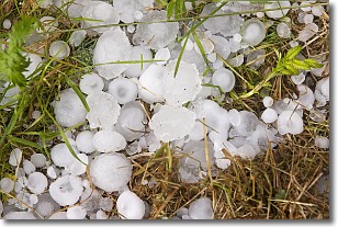
Hail is a form of precipitation which is recognized by large solid balls or
clumps of ice. Hail is created by thunderstorm clouds with strong updrafts of wind.
As the hailstones remain in the updraft, ice is deposited onto them until their
weight becomes heavy enough for them to fall to the earth's surface.
Hail storms can cause significant damage to crops, aircrafts, and man-made structures,
despite the fact that the duration is usually less than ten minutes.
Next Topic: Hole Punch Clouds
Weather Topic: What are Mammatus Clouds?
Home - Education - Cloud Types - Mammatus Clouds
 Next Topic: Nimbostratus Clouds
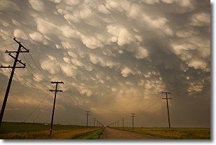
A mammatus cloud is a cloud with a unique feature which resembles
a web of pouches hanging along the base of the cloud.
In the United States, mammatus clouds tend to form in the warmer months, commonly
in the Midwest and eastern regions.
While they usually form at the bottom of a cumulonimbis cloud, they can also form
under altostratus, altocumulus, stratocumulus, and cirrus clouds. Mammatus clouds
warn that severe weather is close.
Next Topic: Nimbostratus Clouds
Current conditions powered by WeatherAPI.com


