Weather Alert in Oregon
Fire Weather Watch issued September 4 at 1:41PM PDT until September 5 at 11:00PM PDT by NWS Pendleton OR
AREAS AFFECTED: John Day Valley; Central Blue Mountains; Southern Blue Mountains; Western Forested Blue Mountains; Warm Springs Reservation
DESCRIPTION: ...HOT, DRY, AND UNSTABLE CONDITIONS ALONG THE WASHINGTON CASCADES TODAY... ...ISOLATED TO SCATTERED THUNDERSTORMS IN CENTRAL AND EASTERN OREGON FRIDAY... .Hot, dry, and unstable conditions will lead to the potential for rapid fire growth on new and existing fires along the Washington Cascades this afternoon and evening. Farther south, isolated to scattered thunderstorms capable of producing abundant cloud-to- ground lightning are forecast Friday for much of central and eastern Oregon. The National Weather Service in Pendleton has issued a Fire Weather Watch for abundant lightning, which is in effect from Friday afternoon through Friday evening. * AFFECTED AREA...Fire Weather Zones 696 John Day Valley, 697 Central Blue Mountains, 698 Southern Blue Mountains, 699 Western Forested Blue Mountains and 703 Warm Springs Reservation. * TIMING...From Friday afternoon through Friday evening. * IMPACTS...Any fire that develops will catch and spread quickly. Outdoor burning is not recommended. * THUNDERSTORMS...Isolated to scattered thunderstorms capable of producing abundant cloud-to-ground lightning and gusty outflow winds. * OUTFLOW WINDS...Gusts up to 50 mph.
INSTRUCTION: A Fire Weather Watch means that critical fire weather conditions are forecast to occur. Listen for later forecasts and possible Red Flag Warnings.
Want more detail? Get the Complete 7 Day and Night Detailed Forecast!
Current U.S. National Radar--Current
The Current National Weather Radar is shown below with a UTC Time (subtract 5 hours from UTC to get Eastern Time).

National Weather Forecast--Current
The Current National Weather Forecast and National Weather Map are shown below.

National Weather Forecast for Tomorrow
Tomorrow National Weather Forecast and Tomorrow National Weather Map are show below.

North America Water Vapor (Moisture)
This map shows recent moisture content over North America. Bright and colored areas show high moisture (ie, clouds); brown indicates very little moisture present; black indicates no moisture.

Weather Topic: What are Cirrus Clouds?
Home - Education - Cloud Types - Cirrus Clouds
 Next Topic: Condensation
Cirrus clouds are high-level clouds that occur above 20,000 feet
and are composed mainly of ice crystals.
They are thin and wispy in appearance.
What do they indicate?
They are often the first sign of an approaching storm.
Next Topic: Condensation
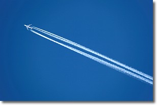
Weather Topic: What are Contrails?
Home - Education - Cloud Types - Contrails
 Next Topic: Cumulonimbus Clouds
A contrail is an artificial cloud, created by the passing of an
aircraft.
Contrails form because water vapor in the exhaust of aircraft engines is suspended
in the air under certain temperatures and humidity conditions. These contrails
are called exhaust contrails.
Another type of contrail can form due to a temporary reduction in air pressure
moving over the plane's surface, causing condensation.
These are called aerodynamic contrails.
When you can see your breath on a cold day, it is also because of condensation.
The reason contrails last longer than the condensation from your breath is
because the water in contrails freezes into ice particles.
Next Topic: Cumulonimbus Clouds
Current conditions powered by WeatherAPI.com


