Weather Alert in Iowa
Winter Weather Advisory issued February 19 at 3:24AM CST until February 20 at 6:00AM CST by NWS Des Moines IA
AREAS AFFECTED: Poweshiek
DESCRIPTION: ...ACCUMULATING SNOWFALL WILL IMPACT TRAVEL FROM LATE THURSDAY INTO FRIDAY... .Precipitation will spread from western into central Iowa on Thursday afternoon and evening. Initially, it may begin as rain or a rain/snow mix before changing to snow. Light to moderate snow accumulations are expected by Friday morning, but a narrow band of heavier snowfall is expected with amounts quickly decreasing on either side of the band. Snow rates may near or exceed 1" per hour at times leading to quickly accumulating snow on roads and slick travel conditions. A small change in the location of the band could alter forecast snow amounts. * WHAT...Snow expected. Total snow accumulations between 2 and 4 inches. * WHERE...Poweshiek County. * WHEN...From 6 PM this evening to 6 AM CST Friday. * IMPACTS...Plan on slippery road conditions. The hazardous conditions could impact the Thursday evening commute. * ADDITIONAL DETAILS...Snow amounts may vary significantly within any one county.
INSTRUCTION: Slow down and use caution while traveling. For the latest travel conditions, check the Iowa 511 app, www.511ia.org, or dial 511.
Want more detail? Get the Complete 7 Day and Night Detailed Forecast!
Current U.S. National Radar--Current
The Current National Weather Radar is shown below with a UTC Time (subtract 5 hours from UTC to get Eastern Time).

National Weather Forecast--Current
The Current National Weather Forecast and National Weather Map are shown below.

National Weather Forecast for Tomorrow
Tomorrow National Weather Forecast and Tomorrow National Weather Map are show below.

North America Water Vapor (Moisture)
This map shows recent moisture content over North America. Bright and colored areas show high moisture (ie, clouds); brown indicates very little moisture present; black indicates no moisture.

Weather Topic: What is Snow?
Home - Education - Precipitation - Snow
 Next Topic: Stratocumulus Clouds
Snow is precipitation taking the form of ice crystals. Each ice crystal, or snowflake,
has unique characteristics, but all of them grow in a hexagonal structure.
Snowfall can last for sustained periods of time and result in significant buildup
of snow on the ground.
On the earth's surface, snow starts out light and powdery, but as it begins to melt
it tends to become more granular, producing small bits of ice which have the consistency of
sand. After several cycles of melting and freezing, snow can become very dense
and ice-like, commonly known as snow pack.
Next Topic: Stratocumulus Clouds
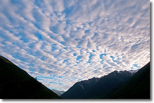
Weather Topic: What are Stratus Clouds?
Home - Education - Cloud Types - Stratus Clouds
 Next Topic: Wall Clouds
Stratus clouds are similar to altostratus clouds, but form at a
lower altitude and are identified by their fog-like appearance, lacking the
distinguishing features of most clouds.
Stratus clouds are wider than most clouds, and their base has a smooth, uniform
look which is lighter in color than a nimbostratus cloud.
The presence of a stratus cloud indicates the possibility of minor precipitation,
such as drizzle, but heavier precipitation does not typically arrive in the form
of a stratus cloud.
Next Topic: Wall Clouds
Current conditions powered by WeatherAPI.com


