Weather Alert in Arkansas
Flood Warning issued April 27 at 10:51AM CDT by NWS Little Rock AR
AREAS AFFECTED: Bradley, AR; Calhoun, AR; Union, AR
DESCRIPTION: ...The Flood Warning is extended for the following rivers in Arkansas... Ouachita River At Thatcher L&D affecting Bradley, Calhoun and Union Counties. For the Ouachita River...including Jones Mill Dcp, Arkadelphia, Camden, Thatcher L&D...Minor flooding is forecast. * WHAT...Minor flooding is occurring and minor flooding is forecast. * WHERE...Ouachita River at Thatcher L&D. * WHEN...Until further notice. * IMPACTS...At 80.0 feet, Minor flooding occurs at this level. Levee gates should be closed to prevent the river from backing into Calion Lake. Access to oil and gas rigs and to timber is flooded. There is wide coverage of flooding in the river bottoms. * ADDITIONAL DETAILS... - At 9:30 AM CDT Sunday the stage was 81.2 feet. - Forecast...The river is expected to fall to 79.2 feet Friday morning. - Flood stage is 79.0 feet. - http://www.weather.gov/safety/flood
INSTRUCTION: Motorists should not attempt to drive around barricades or drive cars through flooded areas. Turn around, don't drown when encountering flooded roads. Most flood deaths occur in vehicles. River forecasts are based on current conditions and rainfall forecasted to occur over the next 24 hours. During periods of flooding...Evening forecasts are reissued with updated rainfall forecasts. Observed and forecasted stage data plots are available on our Advanced Hydrologic Prediction Service web page at... www.weather.gov/lzk Under the Current Conditions section...Select River and Lakes AHPS. The next statement will be issued Monday morning at 1100 AM CDT.
Want more detail? Get the Complete 7 Day and Night Detailed Forecast!
Current U.S. National Radar--Current
The Current National Weather Radar is shown below with a UTC Time (subtract 5 hours from UTC to get Eastern Time).

National Weather Forecast--Current
The Current National Weather Forecast and National Weather Map are shown below.

National Weather Forecast for Tomorrow
Tomorrow National Weather Forecast and Tomorrow National Weather Map are show below.

North America Water Vapor (Moisture)
This map shows recent moisture content over North America. Bright and colored areas show high moisture (ie, clouds); brown indicates very little moisture present; black indicates no moisture.

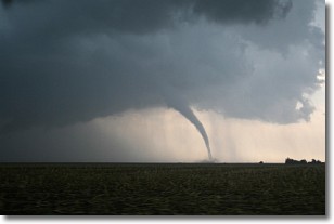
Weather Topic: What are Wall Clouds?
Home - Education - Cloud Types - Wall Clouds
 Next Topic: Altocumulus Clouds
A wall cloud forms underneath the base of a cumulonimbus cloud,
and can be a hotbed for deadly tornadoes.
Wall clouds are formed by air flowing into the cumulonimbus clouds, which can
result in the wall cloud descending from the base of the cumulonimbus cloud, or
rising fractus clouds which join to the base of the storm cloud as the wall cloud
takes shape.
Wall clouds can be very large, and in the Northern Hemisphere they generally
form at the southern edge of cumulonimbus clouds.
Next Topic: Altocumulus Clouds
Weather Topic: What are Altostratus Clouds?
Home - Education - Cloud Types - Altostratus Clouds
 Next Topic: Cirrocumulus Clouds
Altostratus clouds form at mid to high-level altitudes
(between 2 and 7 km) and are created by a warm, stable air mass which causes
water vapor
to condense as it rise through the atmosphere. Usually altostratus clouds are
featureless sheets characterized by a uniform color.
In some cases, wind punching through the cloud formation may give it a waved
appearance, called altostratus undulatus. Altostratus clouds
are commonly seen with other cloud formations accompanying them.
Next Topic: Cirrocumulus Clouds
Current conditions powered by WeatherAPI.com


