Weather Alert in Montana
Flash Flood Watch issued August 26 at 2:53AM MDT until August 28 at 12:00AM MDT by NWS Great Falls MT
AREAS AFFECTED: Missouri Headwaters; Madison River Valley; Beaverhead and Western Madison below 6000ft; Ruby Mountains and Southern Beaverhead Mountains; Gallatin and Madison County Mountains and Centennial Mountains
DESCRIPTION: * WHAT...Flash flooding and debris flows caused by excessive rainfall are possible over the recent burn scars across Madison County. Rainfall amounts of 1 to 2 inches are possible in less than one hour from thunderstorms. * WHERE...The recent burn scars across Madison County, with the greatest impacts from debris flow possible on the Cloudrest, Bivens Creek, and McAllister burn scars. * WHEN...From Wednesday afternoon through Wednesday evening. * IMPACTS...Heavy rainfall over the recent burn scars across Madison County is expected up to and during the period of the watch. Residents near the recent burn scars across Madison County should prepare for potential flooding impacts. Be sure to stay up to date with information from local authorities. Heavy rainfall could trigger flash flooding of low-lying areas and debris flows in and near recent wildfire burn scars. * ADDITIONAL DETAILS... - National Weather Service Meteorologists are forecasting heavy rainfall over the burn scar, which may lead to flash flooding and debris flows. - http://www.weather.gov/safety/flood
INSTRUCTION: PLAN NOW so you will know what to do in an emergency. Keep informed by listening to local radio and television for statements and possible warnings. Follow the advice of public safety officials.
Want more detail? Get the Complete 7 Day and Night Detailed Forecast!
Current U.S. National Radar--Current
The Current National Weather Radar is shown below with a UTC Time (subtract 5 hours from UTC to get Eastern Time).

National Weather Forecast--Current
The Current National Weather Forecast and National Weather Map are shown below.

National Weather Forecast for Tomorrow
Tomorrow National Weather Forecast and Tomorrow National Weather Map are show below.

North America Water Vapor (Moisture)
This map shows recent moisture content over North America. Bright and colored areas show high moisture (ie, clouds); brown indicates very little moisture present; black indicates no moisture.

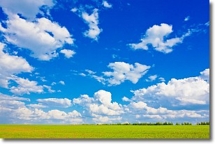
Weather Topic: What are Cumulus Clouds?
Home - Education - Cloud Types - Cumulus Clouds
 Next Topic: Drizzle
Cumulus clouds are fluffy and textured with rounded tops, and
may have flat bottoms. The border of a cumulus cloud
is clearly defined, and can have the appearance of cotton or cauliflower.
Cumulus clouds form at low altitudes (rarely above 2 km) but can grow very tall,
becoming cumulus congestus and possibly the even taller cumulonimbus clouds.
When cumulus clouds become taller, they have a greater chance of producing precipitation.
Next Topic: Drizzle
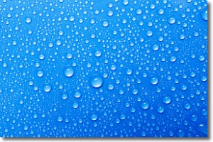
Weather Topic: What is Evaporation?
Home - Education - Precipitation - Evaporation
 Next Topic: Fog
Evaporation is the process which returns water from the earth
back to the atmosphere, and is another crucial process in the water cycle.
Evaporation is the transformation of liquid into gas, and it happens because
molecules are excited by the application of energy and turn into vapor.
In order for water to evaporate it has to be on the surface of a body of water.
Next Topic: Fog
Current conditions powered by WeatherAPI.com


