Weather Alert in Kentucky
Flood Watch issued February 19 at 10:02PM EST until February 20 at 7:00AM EST by NWS Charleston WV
AREAS AFFECTED: Greenup; Carter; Boyd; Lawrence; Gallia; Lawrence; Wayne; Cabell; Mason; Jackson; Lincoln; Putnam; Kanawha; Roane; Wirt; Calhoun; Ritchie; Doddridge; Boone; Clay; Braxton; Gilmer; Lewis; Harrison; Taylor; Upshur; Barbour; Northwest Fayette; Southeast Fayette; Northwest Nicholas; Southeast Nicholas; Northwest Webster; Southeast Webster; Northwest Randolph; Southeast Randolph
DESCRIPTION: * WHAT...Flooding caused by excessive rainfall continues to be possible. * WHERE...Portions of northeast Kentucky, including the following counties, Boyd, Carter, Greenup and Lawrence, southeast Ohio, including the following counties, Gallia and Lawrence OH, and West Virginia, including the following counties, Barbour, Boone, Braxton, Cabell, Calhoun, Clay, Doddridge, Gilmer, Harrison, Jackson WV, Kanawha, Lewis, Lincoln, Mason, Northwest Fayette, Northwest Nicholas, Northwest Randolph, Northwest Webster, Putnam, Ritchie, Roane, Southeast Fayette, Southeast Nicholas, Southeast Randolph, Southeast Webster, Taylor, Upshur, Wayne and Wirt. * WHEN...Until 7 AM EST Friday. * IMPACTS...Creeks and streams may rise out of their banks. Area creeks and streams are running high and could flood with more heavy rain. * ADDITIONAL DETAILS... - Quick hitting rainfall amounts of 0.75 to 1.00 inch are expected within strong thunderstorms. Combined with already elevated streamflows poses a threat for localized flooding. Additionally, Additional rainfall overnight combined with already elevated streamflows poses a threat for localized flooding. Elevations above 3,500 feet will see the added hydrologic element of snow and ice melt further contributing to river and stream rises. - http://www.weather.gov/safety/flood
INSTRUCTION: You should monitor later forecasts and be alert for possible Flood Warnings. Those living in areas prone to flooding should be prepared to take action should flooding develop. Additional information can be found at https://www.weather.gov/rlx as well as on our X and Facebook pages.
Want more detail? Get the Complete 7 Day and Night Detailed Forecast!
Current U.S. National Radar--Current
The Current National Weather Radar is shown below with a UTC Time (subtract 5 hours from UTC to get Eastern Time).

National Weather Forecast--Current
The Current National Weather Forecast and National Weather Map are shown below.

National Weather Forecast for Tomorrow
Tomorrow National Weather Forecast and Tomorrow National Weather Map are show below.

North America Water Vapor (Moisture)
This map shows recent moisture content over North America. Bright and colored areas show high moisture (ie, clouds); brown indicates very little moisture present; black indicates no moisture.

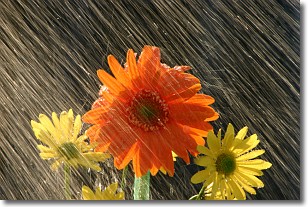
Weather Topic: What is Precipitation?
Home - Education - Precipitation - Precipitation
 Next Topic: Rain
Precipitation can refer to many different forms of water that
may fall from clouds. Precipitation occurs after a cloud has become saturated to
the point where its water particles are more dense than the air below the cloud.
In most cases, precipitation will reach the ground, but it is not uncommon for
precipitation to evaporate before it reaches the earth's surface.
When precipitation evaporates before it contacts the ground it is called Virga.
Graupel, hail, sleet, rain, drizzle, and snow are forms of precipitation, but fog
and mist are not considered precipitation because the water vapor which
constitutes them isn't dense enough to fall to the ground.
Next Topic: Rain
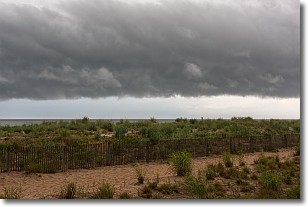
Weather Topic: What are Shelf Clouds?
Home - Education - Cloud Types - Shelf Clouds
 Next Topic: Sleet
A shelf cloud is similar to a wall cloud, but forms at the front
of a storm cloud, instead of at the rear, where wall clouds form.
A shelf cloud is caused by a series of events set into motion by the advancing
storm; first, cool air settles along the ground where precipitation has just fallen.
As the cool air is brought in, the warmer air is displaced, and rises above it,
because it is less dense. When the warmer air reaches the bottom of the storm cloud,
it begins to cool again, and the resulting condensation is a visible shelf cloud.
Next Topic: Sleet
Current conditions powered by WeatherAPI.com


