Weather Alert in North Carolina
Flood Advisory issued June 13 at 7:59PM EDT until June 13 at 11:00PM EDT by NWS Blacksburg VA
AREAS AFFECTED: Alleghany, NC; Grayson, VA
DESCRIPTION: * WHAT...Flooding caused by excessive rainfall is expected. * WHERE...Portions of northwest North Carolina, including the following county, Alleghany NC and southwest Virginia, including the following county, Grayson. * WHEN...Until 1100 PM EDT. * IMPACTS...Minor flooding in low-lying and poor drainage areas. Dangerous flows over low-water crossings. Water over roadways. Overflowing poor drainage areas. Some low-water crossings may become impassable. * ADDITIONAL DETAILS... - At 759 PM EDT, Doppler radar indicated heavy rain due to thunderstorms. Minor flooding is ongoing or expected to begin shortly in the advisory area. Between 1 and 2 inches of rain have fallen. - This includes the following streams and drainages... Fox Creek, Glade Creek, Beaverdam Creek, Bear Branch, Grassy Creek, Elk Creek, Glady Fork, Beaver Creek, Farmers Branch, Brush Creek, Bridle Creek, Crab Fork and Little Peach Bottom Creek. Additional rainfall amounts of 0.5 to 1.5 inches are expected over the area. This additional rain will result in minor flooding. - Some locations that will experience flooding include... Sparta... Independence... Ennice... Mouth Of Wilson... Twin Oaks... Stratford... Bridle Creek... - http://www.weather.gov/safety/flood
INSTRUCTION: Turn around, don't drown when encountering flooded roads. Most flood deaths occur in vehicles. Be aware of your surroundings and do not drive on flooded roads. Stay away or be swept away. River banks and culverts can become unstable and unsafe. When it is safe to do so, please send your reports of flooding, including mudslides or flooded roads, to the National Weather Service by calling toll free at 1...8 6 6...2 1 5...4 3 2 4. Reports and pictures can also be shared on the National Weather Service Blacksburg Facebook page and on Twitter.
Want more detail? Get the Complete 7 Day and Night Detailed Forecast!
Current U.S. National Radar--Current
The Current National Weather Radar is shown below with a UTC Time (subtract 5 hours from UTC to get Eastern Time).

National Weather Forecast--Current
The Current National Weather Forecast and National Weather Map are shown below.

National Weather Forecast for Tomorrow
Tomorrow National Weather Forecast and Tomorrow National Weather Map are show below.

North America Water Vapor (Moisture)
This map shows recent moisture content over North America. Bright and colored areas show high moisture (ie, clouds); brown indicates very little moisture present; black indicates no moisture.

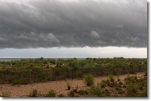
Weather Topic: What are Shelf Clouds?
Home - Education - Cloud Types - Shelf Clouds
 Next Topic: Sleet
A shelf cloud is similar to a wall cloud, but forms at the front
of a storm cloud, instead of at the rear, where wall clouds form.
A shelf cloud is caused by a series of events set into motion by the advancing
storm; first, cool air settles along the ground where precipitation has just fallen.
As the cool air is brought in, the warmer air is displaced, and rises above it,
because it is less dense. When the warmer air reaches the bottom of the storm cloud,
it begins to cool again, and the resulting condensation is a visible shelf cloud.
Next Topic: Sleet
Weather Topic: What is Snow?
Home - Education - Precipitation - Snow
 Next Topic: Stratocumulus Clouds
Snow is precipitation taking the form of ice crystals. Each ice crystal, or snowflake,
has unique characteristics, but all of them grow in a hexagonal structure.
Snowfall can last for sustained periods of time and result in significant buildup
of snow on the ground.
On the earth's surface, snow starts out light and powdery, but as it begins to melt
it tends to become more granular, producing small bits of ice which have the consistency of
sand. After several cycles of melting and freezing, snow can become very dense
and ice-like, commonly known as snow pack.
Next Topic: Stratocumulus Clouds
Current conditions powered by WeatherAPI.com


