Weather Alert in North Carolina
High Wind Watch issued February 5 at 1:04PM EST until February 7 at 7:00PM EST by NWS Greenville-Spartanburg SC
AREAS AFFECTED: Avery; Alexander; Yancey; Mitchell; Buncombe; Southern Jackson; Transylvania; Henderson; Caldwell Mountains; Greater Caldwell; Burke Mountains; Greater Burke; McDowell Mountains; Eastern McDowell; Rutherford Mountains; Greater Rutherford; Polk Mountains; Eastern Polk; Greenville Mountains
DESCRIPTION: * WHAT...Northwest winds 20 to 30 mph with gusts up to 65 mph possible. * WHERE...Portions of western North Carolina and Upstate South Carolina. * WHEN...From Friday evening through Saturday evening. * IMPACTS...Damaging winds could blow down trees and power lines. Widespread power outages are possible. Travel could be difficult, especially for high profile vehicles. * ADDITIONAL DETAILS...The strong winds will result in cold wind chills across the mountains early Saturday morning, and some blowing snow near the Tennessee border.
INSTRUCTION: Be prepared for possible power outages. Take time now to fasten or shelter loose objects in a safe location prior to the onset of high winds. Stay tuned to NOAA Weather Radio or your favorite source of weather information for the latest updates. Additional details can be found at www.weather.gov/gsp.
Want more detail? Get the Complete 7 Day and Night Detailed Forecast!
Current U.S. National Radar--Current
The Current National Weather Radar is shown below with a UTC Time (subtract 5 hours from UTC to get Eastern Time).

National Weather Forecast--Current
The Current National Weather Forecast and National Weather Map are shown below.

National Weather Forecast for Tomorrow
Tomorrow National Weather Forecast and Tomorrow National Weather Map are show below.

North America Water Vapor (Moisture)
This map shows recent moisture content over North America. Bright and colored areas show high moisture (ie, clouds); brown indicates very little moisture present; black indicates no moisture.

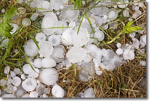
Weather Topic: What is Hail?
Home - Education - Precipitation - Hail
 Next Topic: Hole Punch Clouds
Hail is a form of precipitation which is recognized by large solid balls or
clumps of ice. Hail is created by thunderstorm clouds with strong updrafts of wind.
As the hailstones remain in the updraft, ice is deposited onto them until their
weight becomes heavy enough for them to fall to the earth's surface.
Hail storms can cause significant damage to crops, aircrafts, and man-made structures,
despite the fact that the duration is usually less than ten minutes.
Next Topic: Hole Punch Clouds
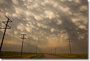
Weather Topic: What are Mammatus Clouds?
Home - Education - Cloud Types - Mammatus Clouds
 Next Topic: Nimbostratus Clouds
A mammatus cloud is a cloud with a unique feature which resembles
a web of pouches hanging along the base of the cloud.
In the United States, mammatus clouds tend to form in the warmer months, commonly
in the Midwest and eastern regions.
While they usually form at the bottom of a cumulonimbis cloud, they can also form
under altostratus, altocumulus, stratocumulus, and cirrus clouds. Mammatus clouds
warn that severe weather is close.
Next Topic: Nimbostratus Clouds
Current conditions powered by WeatherAPI.com


