Weather Alert in Oregon
Red Flag Warning issued September 5 at 2:32PM PDT until September 5 at 11:00PM PDT by NWS Pendleton OR
AREAS AFFECTED: John Day Valley; Central Blue Mountains; Southern Blue Mountains; Western Forested Blue Mountains; Central Mountains of Oregon; Northern Deschutes National Forest; Southern Deschutes National Forest
DESCRIPTION: ...ISOLATED TO SCATTERED THUNDERSTORMS IN CENTRAL AND EASTERN OREGON TODAY... .Isolated to scattered thunderstorms capable of producing abundant cloud-to-ground lightning are forecast through this evening for much of central and eastern Oregon. Some storms will produce a wetting rain. * AFFECTED AREA...Fire Weather Zones 696 John Day Valley, 697 Central Blue Mountains, 698 Southern Blue Mountains, 699 Western Forested Blue Mountains, 700 Central Mountains of Oregon, 704 Northern Deschutes National Forest and 705 Southern Deschutes National Forest. * TIMING...Until 11 PM PDT this evening. * IMPACTS...Any fire that develops will catch and spread quickly. Outdoor burning is not recommended. * THUNDERSTORMS...Isolated to scattered thunderstorms capable of producing abundant cloud-to-ground lightning and gusty outflow winds. * OUTFLOW WINDS...Gusts up to 50 mph.
INSTRUCTION: A Red Flag Warning means that critical fire weather conditions are either occurring now, or will shortly. A combination of strong winds, low relative humidity, and warm temperatures can contribute to extreme fire behavior.
Want more detail? Get the Complete 7 Day and Night Detailed Forecast!
Current U.S. National Radar--Current
The Current National Weather Radar is shown below with a UTC Time (subtract 5 hours from UTC to get Eastern Time).

National Weather Forecast--Current
The Current National Weather Forecast and National Weather Map are shown below.

National Weather Forecast for Tomorrow
Tomorrow National Weather Forecast and Tomorrow National Weather Map are show below.

North America Water Vapor (Moisture)
This map shows recent moisture content over North America. Bright and colored areas show high moisture (ie, clouds); brown indicates very little moisture present; black indicates no moisture.

Weather Topic: What are Stratocumulus Clouds?
Home - Education - Cloud Types - Stratocumulus Clouds
 Next Topic: Stratus Clouds
Stratocumulus clouds are similar to altocumulus clouds in their
fluffy appearance, but have a slightly darker shade due to their additional mass.
A good way to distinguish the two cloud types is to hold your hand out and measure
the size of an individual cloud; if it is the size of your thumb it is generally
an altocumulus cloud, if it is the size of your hand it is generally a
stratocumulus cloud.
It is uncommon for stratocumulus clouds to produce precipitation, but if they do
it is usually a light rain or snow.
Next Topic: Stratus Clouds
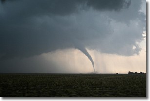
Weather Topic: What are Wall Clouds?
Home - Education - Cloud Types - Wall Clouds
 Next Topic: Altocumulus Clouds
A wall cloud forms underneath the base of a cumulonimbus cloud,
and can be a hotbed for deadly tornadoes.
Wall clouds are formed by air flowing into the cumulonimbus clouds, which can
result in the wall cloud descending from the base of the cumulonimbus cloud, or
rising fractus clouds which join to the base of the storm cloud as the wall cloud
takes shape.
Wall clouds can be very large, and in the Northern Hemisphere they generally
form at the southern edge of cumulonimbus clouds.
Next Topic: Altocumulus Clouds
Current conditions powered by WeatherAPI.com


