Weather Alert in Arkansas
Special Weather Statement issued February 19 at 1:17AM CST by NWS Little Rock AR
AREAS AFFECTED: Fulton; Sharp; Stone; Izard; Independence; Cleburne; Conway; Faulkner; White; Perry; Garland; Saline; Pulaski; Pike; Clark; Hot Spring; Southeast Van Buren County; Northern Scott County; Northwest Yell County; Polk County Lower Elevations; Central and Eastern Montgomery County; Van Buren County Higher Elevations; Central and Southern Scott County; Yell Excluding Northwest; Northern Polk County Higher Elevations; Northern Montgomery County Higher Elevations; Southeast Polk County Higher Elevations; Southwest Montgomery County Higher Elevations
DESCRIPTION: Expect south to southwesterly winds around 10 to 20 mph by Thursday afternoon with some gusts in excess of 30 mph at times. Very dry air will be located over the area with minimum afternoon RH values between 15 to 30 percent. This will make it possible for wildfires to ignite and spread rapidly. Outdoor burning is not recommended. If a wildfire is observed, report it by dialing 911 or by contacting the Arkansas Forestry Division at (800) 468-8834.
INSTRUCTION: N/A
Want more detail? Get the Complete 7 Day and Night Detailed Forecast!
Current U.S. National Radar--Current
The Current National Weather Radar is shown below with a UTC Time (subtract 5 hours from UTC to get Eastern Time).

National Weather Forecast--Current
The Current National Weather Forecast and National Weather Map are shown below.

National Weather Forecast for Tomorrow
Tomorrow National Weather Forecast and Tomorrow National Weather Map are show below.

North America Water Vapor (Moisture)
This map shows recent moisture content over North America. Bright and colored areas show high moisture (ie, clouds); brown indicates very little moisture present; black indicates no moisture.

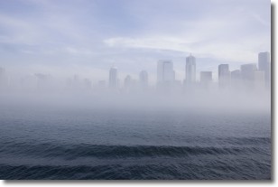
Weather Topic: What is Fog?
Home - Education - Cloud Types - Fog
 Next Topic: Fractus Clouds
Fog is technically a type of stratus cloud, which lies along the
ground and obscures visibility.
It is usually created when humidity in the air condenses into tiny water droplets.
Because of this, some places are more prone to foggy weather, such as regions
close to a body of water.
Fog is similar to mist; both are the appearance of water droplets suspended in
the air, but fog is the term applied to the condition when visibility is less than 1 km.
Next Topic: Fractus Clouds
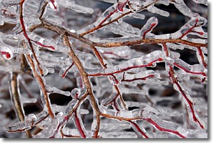
Weather Topic: What is Freezing Rain?
Home - Education - Precipitation - Freezing Rain
 Next Topic: Graupel
Freezing rain is a condition where precipitation which has fallen in the form of
water droplets reaches temperatures which are below freezing and freezes upon
coming into contact
with surface objects. The result of this precipitation is a glaze of ice which
can be damaging to plants and man-made structures. A severe onset of freezing
rain which results in a very thick glaze of ice is known as an ice storm.
Next Topic: Graupel
Current conditions powered by WeatherAPI.com


