Weather Alert in Washington
Fire Weather Watch issued July 28 at 12:33PM PDT until July 30 at 9:00PM PDT by NWS Spokane WA
AREAS AFFECTED: East Washington Central Cascades
DESCRIPTION: ...HOT, DRY, AND UNSTABLE CONDITIONS WITH ISOLATED DRY THUNDERSTORMS WEDNESDAY AFTERNOON AND EVENING... The National Weather Service in Spokane has issued a Fire Weather Watch for hot, dry, and unstable conditions with isolated dry thunderstorms, which is in effect from Wednesday afternoon through Wednesday evening. * Affected Area: East Washington Central Cascades (Zone 696). * Timing: Wednesday afternoon and evening. * Relative Humidities: Min RH 20 to 30 percent. * Temperatures: 80-90 degrees. * Lightning: Isolated dry thunderstorms. * Outflow Winds: Gusty and erratic winds are possible with any thunderstorms that develop. The outflow winds could travel quite a distance from the core of the storm. * Impacts: Hot, dry, and unstable conditions Wednesday afternoon and evening may lead to rapid fire growth on any new or existing fires. Isolated dry thunderstorms will lead to the potential for new fire starts. Gusty winds with thunderstorms may result in rapid fire spread with any new or existing fires.
INSTRUCTION: A Fire Weather Watch means that critical fire weather conditions are forecast to occur. Listen for later forecasts and possible Red Flag Warnings.
Want more detail? Get the Complete 7 Day and Night Detailed Forecast!
Current U.S. National Radar--Current
The Current National Weather Radar is shown below with a UTC Time (subtract 5 hours from UTC to get Eastern Time).

National Weather Forecast--Current
The Current National Weather Forecast and National Weather Map are shown below.

National Weather Forecast for Tomorrow
Tomorrow National Weather Forecast and Tomorrow National Weather Map are show below.

North America Water Vapor (Moisture)
This map shows recent moisture content over North America. Bright and colored areas show high moisture (ie, clouds); brown indicates very little moisture present; black indicates no moisture.

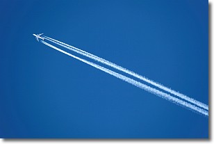
Weather Topic: What are Contrails?
Home - Education - Cloud Types - Contrails
 Next Topic: Cumulonimbus Clouds
A contrail is an artificial cloud, created by the passing of an
aircraft.
Contrails form because water vapor in the exhaust of aircraft engines is suspended
in the air under certain temperatures and humidity conditions. These contrails
are called exhaust contrails.
Another type of contrail can form due to a temporary reduction in air pressure
moving over the plane's surface, causing condensation.
These are called aerodynamic contrails.
When you can see your breath on a cold day, it is also because of condensation.
The reason contrails last longer than the condensation from your breath is
because the water in contrails freezes into ice particles.
Next Topic: Cumulonimbus Clouds
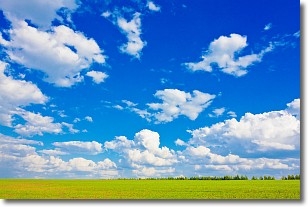
Weather Topic: What are Cumulus Clouds?
Home - Education - Cloud Types - Cumulus Clouds
 Next Topic: Drizzle
Cumulus clouds are fluffy and textured with rounded tops, and
may have flat bottoms. The border of a cumulus cloud
is clearly defined, and can have the appearance of cotton or cauliflower.
Cumulus clouds form at low altitudes (rarely above 2 km) but can grow very tall,
becoming cumulus congestus and possibly the even taller cumulonimbus clouds.
When cumulus clouds become taller, they have a greater chance of producing precipitation.
Next Topic: Drizzle
Current conditions powered by WeatherAPI.com


