Weather Alert in Washington
Fire Weather Watch issued July 28 at 12:33PM PDT until July 30 at 9:00PM PDT by NWS Spokane WA
AREAS AFFECTED: East Washington Central Cascades
DESCRIPTION: ...HOT, DRY, AND UNSTABLE CONDITIONS WITH ISOLATED DRY THUNDERSTORMS WEDNESDAY AFTERNOON AND EVENING... The National Weather Service in Spokane has issued a Fire Weather Watch for hot, dry, and unstable conditions with isolated dry thunderstorms, which is in effect from Wednesday afternoon through Wednesday evening. * Affected Area: East Washington Central Cascades (Zone 696). * Timing: Wednesday afternoon and evening. * Relative Humidities: Min RH 20 to 30 percent. * Temperatures: 80-90 degrees. * Lightning: Isolated dry thunderstorms. * Outflow Winds: Gusty and erratic winds are possible with any thunderstorms that develop. The outflow winds could travel quite a distance from the core of the storm. * Impacts: Hot, dry, and unstable conditions Wednesday afternoon and evening may lead to rapid fire growth on any new or existing fires. Isolated dry thunderstorms will lead to the potential for new fire starts. Gusty winds with thunderstorms may result in rapid fire spread with any new or existing fires.
INSTRUCTION: A Fire Weather Watch means that critical fire weather conditions are forecast to occur. Listen for later forecasts and possible Red Flag Warnings.
Want more detail? Get the Complete 7 Day and Night Detailed Forecast!
Current U.S. National Radar--Current
The Current National Weather Radar is shown below with a UTC Time (subtract 5 hours from UTC to get Eastern Time).

National Weather Forecast--Current
The Current National Weather Forecast and National Weather Map are shown below.

National Weather Forecast for Tomorrow
Tomorrow National Weather Forecast and Tomorrow National Weather Map are show below.

North America Water Vapor (Moisture)
This map shows recent moisture content over North America. Bright and colored areas show high moisture (ie, clouds); brown indicates very little moisture present; black indicates no moisture.

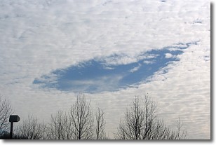
Weather Topic: What are Hole Punch Clouds?
Home - Education - Cloud Types - Hole Punch Clouds
 Next Topic: Mammatus Clouds
A hole punch cloud is an unusual occurrence when a disk-shaped
hole appears in a cirrostratus, cirrocumulus, or altocumulus cloud.
When part of the cloud forms ice crystals, water droplets in the surrounding area
of the cloud evaporate. The effect of this process produces a large elliptical
gap in the cloud. The hole punch cloud formation is rare, but it is not specific
to any geographic area.
Other names which have been used to describe this phenomena include fallstreak hole,
skypunch, and cloud hole.
Next Topic: Mammatus Clouds
Weather Topic: What are Nimbostratus Clouds?
Home - Education - Cloud Types - Nimbostratus Clouds
 Next Topic: Precipitation
A nimbostratus cloud is similar to a stratus cloud in its formless,
smooth appearance. However, a nimbostratus cloud is darker than a stratus cloud,
because it is thicker.
Unlike a stratus cloud, a nimbostratus cloud typically brings with it the threat
of moderate to heavy precipitation. In some cases, the precipitation may evaporate
before reaching the ground, a phenomenon known as virga.
Next Topic: Precipitation
Current conditions powered by WeatherAPI.com


