Weather Alert in Kansas
Flood Warning issued August 28 at 4:04AM CDT until August 28 at 12:00PM CDT by NWS Wichita KS
AREAS AFFECTED: Cowley, KS; Kingman, KS; Reno, KS; Sedgwick, KS; Sumner, KS
DESCRIPTION: * WHAT...Flooding caused by excessive rainfall is possible. * WHERE...A portion of South Central Kansas, including the following counties, Cowley, Kingman, Reno, Sedgwick and Sumner. * WHEN...Until noon CDT Thursday. * IMPACTS...Flooding of rivers, creeks, streams, city streets, and other low-lying and flood-prone locations is possible. * ADDITIONAL DETAILS... - At 402 AM CDT, Doppler radar indicated heavy rain due to thunderstorms. Up to 3 inches of rain have fallen so far, with an additional 1 to 3 inches possible in the warned area through Thursday morning. - Some locations that may experience flooding include... Wichita, Derby, Arkansas City, Winfield, Andover, Haysville, Wellington, Park City, Valley Center, Bel Aire, Mulvane, Goddard, Rose Hill, Maize, Kingman, Clearwater, Cheney, Sedgwick, Belle Plaine and Colwich.
INSTRUCTION: Do not drive into flooded areas or go around barricades. Nearly two feet of water will carry most vehicles away. Turn around, don't drown. Be especially cautious at night when it is harder to recognize the dangers of flooding.
Want more detail? Get the Complete 7 Day and Night Detailed Forecast!
Current U.S. National Radar--Current
The Current National Weather Radar is shown below with a UTC Time (subtract 5 hours from UTC to get Eastern Time).

National Weather Forecast--Current
The Current National Weather Forecast and National Weather Map are shown below.

National Weather Forecast for Tomorrow
Tomorrow National Weather Forecast and Tomorrow National Weather Map are show below.

North America Water Vapor (Moisture)
This map shows recent moisture content over North America. Bright and colored areas show high moisture (ie, clouds); brown indicates very little moisture present; black indicates no moisture.

Weather Topic: What is Graupel?
Home - Education - Precipitation - Graupel
 Next Topic: Hail
Graupel is a form of precipitation that is created by atmospheric conditions
which cause supercooled water droplets to contact snow crystals and freeze to
their surface.
Sometimes known as soft hail or snow pellets, graupel is delicate and easily
destroyed by touch. Whereas hail usually falls during severe weather, graupel
doesn't require such conditions to form, and can form in mild precipitation
similar to situations which produce snowfall.
Next Topic: Hail
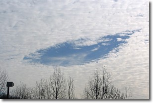
Weather Topic: What are Hole Punch Clouds?
Home - Education - Cloud Types - Hole Punch Clouds
 Next Topic: Mammatus Clouds
A hole punch cloud is an unusual occurrence when a disk-shaped
hole appears in a cirrostratus, cirrocumulus, or altocumulus cloud.
When part of the cloud forms ice crystals, water droplets in the surrounding area
of the cloud evaporate. The effect of this process produces a large elliptical
gap in the cloud. The hole punch cloud formation is rare, but it is not specific
to any geographic area.
Other names which have been used to describe this phenomena include fallstreak hole,
skypunch, and cloud hole.
Next Topic: Mammatus Clouds
Current conditions powered by WeatherAPI.com


