Weather Alert in Texas
Fire Warning issued February 18 at 9:48PM CST by NWS Amarillo TX
AREAS AFFECTED: Potter
DESCRIPTION: FRWAMA THE NATIONAL WEATHER SERVICE IN AMARILLO HAS ISSUED A FIRE WARNING AT THE REQUEST OF AMARILLO AREA OFFICE OF EMERGENCY MANAGEMENT FOR NORTHERN POTTER COUNTY. * AT 944 PM CST...A DANGEROUS WILDFIRE WAS LOCATED 8 MILES SOUTHEAST OF MASTERSON...OR 22 MILES NORTH OF AMARILLO...MOVING EAST TO NORTHEAST AT 2 TO 4 MPH. * AREAS IMPACTED... HIGHWAY 87 NORTH OF AMARILLO IN THE VICINITY OF THE CANADIAN RIVER. AND ALONG THE CANADIAN RIVER VALLEY JUST EAST OF HIGHWAY 87. * ADDITIONAL INFORMATION...SMOKE AND FIRE WILL PRESENT A THREAT TO LIFE AND PROPERTY.
INSTRUCTION: BE PREPARED TO EVACUATE QUICKLY IF REQUESTED AND FOLLOW ALL SAFETY INSTRUCTIONS FROM LOCAL EMERGENCY MANAGEMENT OFFICIALS. DO NOT DRIVE INTO SMOKE.
Want more detail? Get the Complete 7 Day and Night Detailed Forecast!
Current U.S. National Radar--Current
The Current National Weather Radar is shown below with a UTC Time (subtract 5 hours from UTC to get Eastern Time).

National Weather Forecast--Current
The Current National Weather Forecast and National Weather Map are shown below.

National Weather Forecast for Tomorrow
Tomorrow National Weather Forecast and Tomorrow National Weather Map are show below.

North America Water Vapor (Moisture)
This map shows recent moisture content over North America. Bright and colored areas show high moisture (ie, clouds); brown indicates very little moisture present; black indicates no moisture.

Weather Topic: What is Hail?
Home - Education - Precipitation - Hail
 Next Topic: Hole Punch Clouds
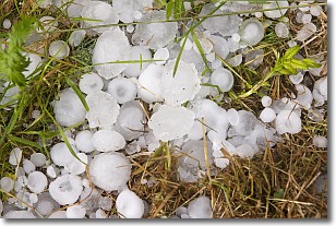
Hail is a form of precipitation which is recognized by large solid balls or
clumps of ice. Hail is created by thunderstorm clouds with strong updrafts of wind.
As the hailstones remain in the updraft, ice is deposited onto them until their
weight becomes heavy enough for them to fall to the earth's surface.
Hail storms can cause significant damage to crops, aircrafts, and man-made structures,
despite the fact that the duration is usually less than ten minutes.
Next Topic: Hole Punch Clouds
Weather Topic: What are Mammatus Clouds?
Home - Education - Cloud Types - Mammatus Clouds
 Next Topic: Nimbostratus Clouds
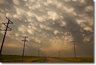
A mammatus cloud is a cloud with a unique feature which resembles
a web of pouches hanging along the base of the cloud.
In the United States, mammatus clouds tend to form in the warmer months, commonly
in the Midwest and eastern regions.
While they usually form at the bottom of a cumulonimbis cloud, they can also form
under altostratus, altocumulus, stratocumulus, and cirrus clouds. Mammatus clouds
warn that severe weather is close.
Next Topic: Nimbostratus Clouds
Current conditions powered by WeatherAPI.com


