Weather Alert in Texas
Flood Advisory issued April 24 at 6:30AM CDT until April 24 at 9:30AM CDT by NWS Fort Worth TX
AREAS AFFECTED: Jack, TX; Montague, TX; Wise, TX
DESCRIPTION: * WHAT...Urban and small stream flooding caused by excessive rainfall is expected. * WHERE...A portion of north central Texas, including the following counties, Jack, Montague and Wise. * WHEN...Until 930 AM CDT. * IMPACTS...Minor flooding in low-lying and poor drainage areas. * ADDITIONAL DETAILS... - Doppler radar indicated heavy rain due to thunderstorms. This will likely cause urban and small stream flooding. Low lying and/or poor drainage areas will experience minor flooding in the advisory area. - Some locations that will experience flooding include... Bowie, Jacksboro, Nocona, Alvord, St. Jo, Chico, Bryson, Lake Amon G Carter, Sunset, Lake Bridgeport, Lake Nocona, Fort Richardson State Park, Nocona Hills, Montague, Cundiff, Fruitland, Park Springs, Crafton, Stoneburg and Mallard.
INSTRUCTION: Turn around, don't drown when encountering flooded roads. Most flood deaths occur in vehicles.
Want more detail? Get the Complete 7 Day and Night Detailed Forecast!
Current U.S. National Radar--Current
The Current National Weather Radar is shown below with a UTC Time (subtract 5 hours from UTC to get Eastern Time).

National Weather Forecast--Current
The Current National Weather Forecast and National Weather Map are shown below.

National Weather Forecast for Tomorrow
Tomorrow National Weather Forecast and Tomorrow National Weather Map are show below.

North America Water Vapor (Moisture)
This map shows recent moisture content over North America. Bright and colored areas show high moisture (ie, clouds); brown indicates very little moisture present; black indicates no moisture.

Weather Topic: What is Drizzle?
Home - Education - Precipitation - Drizzle
 Next Topic: Evaporation
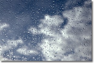
Drizzle is precipitation in the form of water droplets which are
smaller than raindrops.
Drizzle is characterized by fine, gently falling droplets and typically does not
impact human habitation in a negative way. The exception to this is freezing drizzle,
a condition where drizzle freezes immediately upon reaching earth's surface.
Freezing drizzle is still less dangerous than freezing rain, but can
potentially result in hazardous road conditions.
Next Topic: Evaporation
Weather Topic: What is Fog?
Home - Education - Cloud Types - Fog
 Next Topic: Fractus Clouds
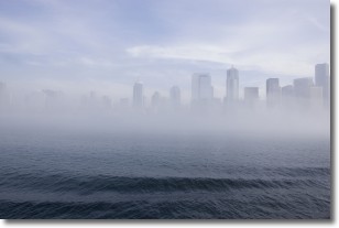
Fog is technically a type of stratus cloud, which lies along the
ground and obscures visibility.
It is usually created when humidity in the air condenses into tiny water droplets.
Because of this, some places are more prone to foggy weather, such as regions
close to a body of water.
Fog is similar to mist; both are the appearance of water droplets suspended in
the air, but fog is the term applied to the condition when visibility is less than 1 km.
Next Topic: Fractus Clouds
Current conditions powered by WeatherAPI.com


