Weather Alert in New Mexico
Red Flag Warning issued February 19 at 11:46AM MST until February 20 at 6:00PM MST by NWS Albuquerque NM
AREAS AFFECTED: Northeast Plains; East Central Plains
DESCRIPTION: ...RED FLAG WARNING TODAY FROM 12 TO 6 PM FOR THE NORTHEAST AND EAST CENTRAL PLAINS, AND THE NORTHEAST HIGHLANDS ALONG AND EAST OF I-25, DUE TO STRONG WINDS AND LOW HUMIDITY... ...RED FLAG WARNING FRIDAY FROM 9 AM TO 6 PM FOR THE EASTERN PLAINS AND THE CENTRAL HIGHLANDS, DUE TO STRONG WINDS AND LOW HUMIDITY... .Persistently strong flow aloft, an area of low pressure at the surface over the northeast corner of New Mexico, and very dry fuels over northeast and east central areas will result in critical fire weather conditions on the eastern plains this afternoon and Friday. The critical fire weather conditions will reach as far west as the I-25 corridor from Las Vegas northward this afternoon, but higher humidities and snow showers should reduce fire weather concerns over the Northeast Highlands on Friday. Meanwhile, drier conditions are forecast across the eastern half of the Central Highlands on Friday, compared to today. The strongest winds are forecast Friday, when gusts will reach up to 50 to 60 mph across much of northeast and east central New Mexico. The National Weather Service in Albuquerque has issued a Red Flag Warning...which is in effect from 9 AM to 6 PM MST Friday. The Fire Weather Watch is no longer in effect. * AREA AND TIMING...Northeast Plains (Zone 104) and the East Central Plains (Zone 126) today from 12 until 6 PM MST, and Friday from 9 AM to 6 PM MST. * 20 FOOT WINDS...For today, west and northwest winds 20 to 30 mph with gusts up to 40 mph. For Friday, west winds 25 to 35 mph with gusts up to 60 mph. * RELATIVE HUMIDITY...For today, minimum values between 10 and 15 percent. For Friday, minimum values between 12 and 17 percent. * IMPACTS...Any fires that develop will likely spread rapidly. Outdoor burning is not recommended.
INSTRUCTION: Please advise the appropriate officials or fire crews in the field of this Red Flag Warning.
Want more detail? Get the Complete 7 Day and Night Detailed Forecast!
Current U.S. National Radar--Current
The Current National Weather Radar is shown below with a UTC Time (subtract 5 hours from UTC to get Eastern Time).

National Weather Forecast--Current
The Current National Weather Forecast and National Weather Map are shown below.

National Weather Forecast for Tomorrow
Tomorrow National Weather Forecast and Tomorrow National Weather Map are show below.

North America Water Vapor (Moisture)
This map shows recent moisture content over North America. Bright and colored areas show high moisture (ie, clouds); brown indicates very little moisture present; black indicates no moisture.

Weather Topic: What is Graupel?
Home - Education - Precipitation - Graupel
 Next Topic: Hail
Graupel is a form of precipitation that is created by atmospheric conditions
which cause supercooled water droplets to contact snow crystals and freeze to
their surface.
Sometimes known as soft hail or snow pellets, graupel is delicate and easily
destroyed by touch. Whereas hail usually falls during severe weather, graupel
doesn't require such conditions to form, and can form in mild precipitation
similar to situations which produce snowfall.
Next Topic: Hail
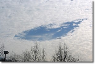
Weather Topic: What are Hole Punch Clouds?
Home - Education - Cloud Types - Hole Punch Clouds
 Next Topic: Mammatus Clouds
A hole punch cloud is an unusual occurrence when a disk-shaped
hole appears in a cirrostratus, cirrocumulus, or altocumulus cloud.
When part of the cloud forms ice crystals, water droplets in the surrounding area
of the cloud evaporate. The effect of this process produces a large elliptical
gap in the cloud. The hole punch cloud formation is rare, but it is not specific
to any geographic area.
Other names which have been used to describe this phenomena include fallstreak hole,
skypunch, and cloud hole.
Next Topic: Mammatus Clouds
Current conditions powered by WeatherAPI.com


