Weather Alert in Colorado
Fire Weather Watch issued February 24 at 12:18PM MST until February 25 at 7:00PM MST by NWS Goodland KS
AREAS AFFECTED: Kit Carson County; Cheyenne; Dundy
DESCRIPTION: ...Strong Winds Expected Wednesday... .Strong westerly winds will spread over the plains of Colorado and adjacent areas Wednesday afternoon. Strong winds, combined with very dry fuels will promote explosive fire growth. A strong cold front is expected to sweep across the area around sunset, shifting winds to the north-northeast making any ongoing fire control efforts difficult. The National Weather Service in Goodland has issued a Fire Weather Watch for wind and low relative humidity, which is in effect from Wednesday morning through Wednesday evening. * AFFECTED AREA...Fire Weather Zones 001 Cheyenne KS, 079 Dundy and 253 Kit Carson. * TIMING...From Wednesday morning through Wednesday evening. * WINDS...Northwest 15 to 25 mph with gusts up to 45 mph. * RELATIVE HUMIDITY...As low as 15 percent. * IMPACTS...Unpredictable fire behavior. Any fires that develop may rapidly grow and spread out of control.
INSTRUCTION: A Fire Weather Watch means that critical fire weather conditions are forecast to occur. Listen for later forecasts and possible red flag warnings.
Want more detail? Get the Complete 7 Day and Night Detailed Forecast!
Current U.S. National Radar--Current
The Current National Weather Radar is shown below with a UTC Time (subtract 5 hours from UTC to get Eastern Time).

National Weather Forecast--Current
The Current National Weather Forecast and National Weather Map are shown below.

National Weather Forecast for Tomorrow
Tomorrow National Weather Forecast and Tomorrow National Weather Map are show below.

North America Water Vapor (Moisture)
This map shows recent moisture content over North America. Bright and colored areas show high moisture (ie, clouds); brown indicates very little moisture present; black indicates no moisture.

Weather Topic: What are Stratus Clouds?
Home - Education - Cloud Types - Stratus Clouds
 Next Topic: Wall Clouds
Stratus clouds are similar to altostratus clouds, but form at a
lower altitude and are identified by their fog-like appearance, lacking the
distinguishing features of most clouds.
Stratus clouds are wider than most clouds, and their base has a smooth, uniform
look which is lighter in color than a nimbostratus cloud.
The presence of a stratus cloud indicates the possibility of minor precipitation,
such as drizzle, but heavier precipitation does not typically arrive in the form
of a stratus cloud.
Next Topic: Wall Clouds
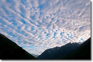
Weather Topic: What are Altocumulus Clouds?
Home - Education - Cloud Types - Altocumulus Clouds
 Next Topic: Altostratus Clouds
Similar to cirrocumulus clouds, altocumulus clouds are
characterized by cloud patches. They are distinguished by larger cloudlets
than cirrocumulus clouds but are still smaller than stratocumulus clouds.
Altocumulus clouds most commonly form in middle altitudes (between 2 and 5 km)
and may resemble, at times, the shape of a flying saucer.
These uncommon formations, called altocumulus lenticularis, are created by uplift
in the atmosphere and are most often seen in close proximity to mountains.
Next Topic: Altostratus Clouds
Current conditions powered by WeatherAPI.com


