Weather Alert in Colorado
Winter Weather Advisory issued February 24 at 12:06PM MST until February 26 at 12:00AM MST by NWS Denver CO
AREAS AFFECTED: South and Southeast Grand/West Central and Southwest Boulder/Gilpin/Clear Creek/Summit/North and West Park Counties Above 9000 Feet
DESCRIPTION: * WHAT...Snow expected. Total snow accumulations 4 to 8 inches, with locally up to 14 inches over the Indian Peaks. * WHERE...The Mountains of Summit County, the Mosquito Range, and the Indian Peaks. * WHEN...From midnight tonight to midnight MST Wednesday Night. * IMPACTS...Snow covered roads will make travel hazardous, especially late Tuesday night into Wednesday morning. * ADDITIONAL DETAILS...Heavy snow is expected to quickly develop this evening and continue through Wednesday morning, before diminishing Wednesday afternoon.
INSTRUCTION: If you must travel, keep an extra flashlight, food, and water in your vehicle in case of an emergency. The latest road conditions for Colorado can be obtained by calling 5 1 1 or by going to www.cotrip.org.
Want more detail? Get the Complete 7 Day and Night Detailed Forecast!
Current U.S. National Radar--Current
The Current National Weather Radar is shown below with a UTC Time (subtract 5 hours from UTC to get Eastern Time).

National Weather Forecast--Current
The Current National Weather Forecast and National Weather Map are shown below.

National Weather Forecast for Tomorrow
Tomorrow National Weather Forecast and Tomorrow National Weather Map are show below.

North America Water Vapor (Moisture)
This map shows recent moisture content over North America. Bright and colored areas show high moisture (ie, clouds); brown indicates very little moisture present; black indicates no moisture.

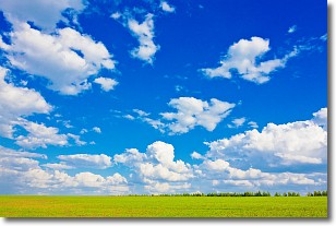
Weather Topic: What are Cumulus Clouds?
Home - Education - Cloud Types - Cumulus Clouds
 Next Topic: Drizzle
Cumulus clouds are fluffy and textured with rounded tops, and
may have flat bottoms. The border of a cumulus cloud
is clearly defined, and can have the appearance of cotton or cauliflower.
Cumulus clouds form at low altitudes (rarely above 2 km) but can grow very tall,
becoming cumulus congestus and possibly the even taller cumulonimbus clouds.
When cumulus clouds become taller, they have a greater chance of producing precipitation.
Next Topic: Drizzle
Weather Topic: What is Evaporation?
Home - Education - Precipitation - Evaporation
 Next Topic: Fog
Evaporation is the process which returns water from the earth
back to the atmosphere, and is another crucial process in the water cycle.
Evaporation is the transformation of liquid into gas, and it happens because
molecules are excited by the application of energy and turn into vapor.
In order for water to evaporate it has to be on the surface of a body of water.
Next Topic: Fog
Current conditions powered by WeatherAPI.com


