Weather Alert in Kansas
Flood Warning issued August 28 at 3:09AM CDT until August 31 at 7:52PM CDT by NWS Wichita KS
AREAS AFFECTED: Cowley, KS
DESCRIPTION: ...The Flood Warning continues for the following rivers in Kansas... Walnut River at Augusta affecting Cowley and Butler Counties. Walnut River at Winfield affecting Cowley and Butler Counties. ...The Flood Warning is extended for the following rivers in Kansas... Walnut River at Arkansas City affecting Cowley County. * WHAT...Minor flooding is forecast. * WHERE...Walnut River at Arkansas City. * WHEN...From Saturday evening to Sunday evening. * IMPACTS...At 18.0 feet, Considerable flooding of farmland can be expected. There is considerable flooding upstream along the west bank of the Walnut River. On the east bank, the ground slopes upward so that only about a 300 foot wide strip of land would be affected. * ADDITIONAL DETAILS... - At 1:15 AM CDT Thursday the stage was 3.3 feet. - Forecast...The river is expected to rise above flood stage Saturday evening to a crest of 18.2 feet early Sunday morning. It will then fall below flood stage Sunday morning. - Flood stage is 18.0 feet.
INSTRUCTION: Do not drive into flooded areas or go around barricades. Nearly two feet of water will carry most vehicles away. Turn around, don't drown. Additional information is available at www.weather.gov. The next statement will be issued this afternoon at 315 PM CDT.
Want more detail? Get the Complete 7 Day and Night Detailed Forecast!
Current U.S. National Radar--Current
The Current National Weather Radar is shown below with a UTC Time (subtract 5 hours from UTC to get Eastern Time).

National Weather Forecast--Current
The Current National Weather Forecast and National Weather Map are shown below.

National Weather Forecast for Tomorrow
Tomorrow National Weather Forecast and Tomorrow National Weather Map are show below.

North America Water Vapor (Moisture)
This map shows recent moisture content over North America. Bright and colored areas show high moisture (ie, clouds); brown indicates very little moisture present; black indicates no moisture.

Weather Topic: What is Freezing Rain?
Home - Education - Precipitation - Freezing Rain
 Next Topic: Graupel
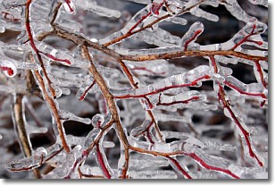
Freezing rain is a condition where precipitation which has fallen in the form of
water droplets reaches temperatures which are below freezing and freezes upon
coming into contact
with surface objects. The result of this precipitation is a glaze of ice which
can be damaging to plants and man-made structures. A severe onset of freezing
rain which results in a very thick glaze of ice is known as an ice storm.
Next Topic: Graupel
Weather Topic: What is Hail?
Home - Education - Precipitation - Hail
 Next Topic: Hole Punch Clouds
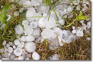
Hail is a form of precipitation which is recognized by large solid balls or
clumps of ice. Hail is created by thunderstorm clouds with strong updrafts of wind.
As the hailstones remain in the updraft, ice is deposited onto them until their
weight becomes heavy enough for them to fall to the earth's surface.
Hail storms can cause significant damage to crops, aircrafts, and man-made structures,
despite the fact that the duration is usually less than ten minutes.
Next Topic: Hole Punch Clouds
Current conditions powered by WeatherAPI.com


