Weather Alert in Indiana
Flood Warning issued February 21 at 7:44PM EST until February 22 at 4:00PM EST by NWS Indianapolis IN
AREAS AFFECTED: Jackson, IN; Lawrence, IN; Washington, IN
DESCRIPTION: ...The Flood Warning is extended for the following rivers in Indiana... East Fork White River at Seymour. .Rainfall amounts of 1 to 1.5 inches have led to rises along many rivers and streams across central and southern Indiana. Brief flooding is occurring along the East Fork White River at Seymour, with the river at crest early Saturday evening at 12.20 feet. The river is expected to fall below flood stage overnight and continue to fall through the week ahead. * WHAT...Minor flooding is occurring and minor flooding is forecast. * WHERE...East Fork White River at Seymour. * WHEN...Until tomorrow afternoon. * IMPACTS...At 12.0 feet, Significant agricultural lands begins to flood. High water affects some local roads. * ADDITIONAL DETAILS... - At 6:45 PM EST Saturday the stage was 12.2 feet. - Recent Activity...The maximum river stage in the 24 hours ending at 6:45 PM EST Saturday was 12.2 feet. - Forecast...The river is expected to rise to a crest of 12.2 feet just after midnight tonight. It will then fall below flood stage late tonight. - Flood stage is 12.0 feet. - http://www.weather.gov/safety/flood
INSTRUCTION: Motorists should not attempt to drive around barricades or drive cars through flooded areas. Be especially cautious at night when it is harder to recognize the dangers of flooding. Additional information is available at www.weather.gov/ind. The next statement should be issued Sunday afternoon by around noon EST.
Want more detail? Get the Complete 7 Day and Night Detailed Forecast!
Current U.S. National Radar--Current
The Current National Weather Radar is shown below with a UTC Time (subtract 5 hours from UTC to get Eastern Time).

National Weather Forecast--Current
The Current National Weather Forecast and National Weather Map are shown below.

National Weather Forecast for Tomorrow
Tomorrow National Weather Forecast and Tomorrow National Weather Map are show below.

North America Water Vapor (Moisture)
This map shows recent moisture content over North America. Bright and colored areas show high moisture (ie, clouds); brown indicates very little moisture present; black indicates no moisture.

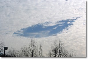
Weather Topic: What are Hole Punch Clouds?
Home - Education - Cloud Types - Hole Punch Clouds
 Next Topic: Mammatus Clouds
A hole punch cloud is an unusual occurrence when a disk-shaped
hole appears in a cirrostratus, cirrocumulus, or altocumulus cloud.
When part of the cloud forms ice crystals, water droplets in the surrounding area
of the cloud evaporate. The effect of this process produces a large elliptical
gap in the cloud. The hole punch cloud formation is rare, but it is not specific
to any geographic area.
Other names which have been used to describe this phenomena include fallstreak hole,
skypunch, and cloud hole.
Next Topic: Mammatus Clouds
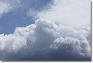
Weather Topic: What are Nimbostratus Clouds?
Home - Education - Cloud Types - Nimbostratus Clouds
 Next Topic: Precipitation
A nimbostratus cloud is similar to a stratus cloud in its formless,
smooth appearance. However, a nimbostratus cloud is darker than a stratus cloud,
because it is thicker.
Unlike a stratus cloud, a nimbostratus cloud typically brings with it the threat
of moderate to heavy precipitation. In some cases, the precipitation may evaporate
before reaching the ground, a phenomenon known as virga.
Next Topic: Precipitation
Current conditions powered by WeatherAPI.com


