Weather Alert in Arizona
Flood Watch issued August 22 at 10:03AM MST until August 25 at 8:00PM MST by NWS Flagstaff AZ
AREAS AFFECTED: Kaibab Plateau; Marble and Glen Canyons; Grand Canyon Country
DESCRIPTION: * WHAT...Flash flooding caused by excessive rainfall is possible. * WHERE...A portion of north central Arizona, including the following areas, Grand Canyon Country, Kaibab Plateau and Marble and Glen Canyons, including the Dragon Bravo and White Sage fire burn scars. * WHEN...From Saturday morning through Monday evening. * IMPACTS...Flash flooding will be possible in creeks, normally dry washes, swimming holes, and over recently burned areas. Raging killer currents will be possible in side canyons and narrow slot canyons. Low-water crossings may be flooded. * ADDITIONAL DETAILS... - Numerous showers and thunderstorms are expected over the next few days, capable of producing heavy rainfall over a short period of time. - Additional information is available at weather.gov/flagstaff.
INSTRUCTION: Have a way to receive Flash Flood Warnings and be prepared to take action should warnings be issued. Consider changing your plans if you were going to hike, boat, or paddleboard to a slot canyon or normally dry wash. If you do still decide to recreate, check in at a nearby visitor center or ranger station. People planning river trips on the Colorado River between Glen Canyon Dam and the west end of Grand Canyon National Park should be aware of the possibility of Flash Flooding from the side canyons and plan accordingly. The White Sage and Dragon Bravo fire burn scars will be especially susceptible to Flash Flooding. Use extreme caution if working in or around these areas.
Want more detail? Get the Complete 7 Day and Night Detailed Forecast!
Current U.S. National Radar--Current
The Current National Weather Radar is shown below with a UTC Time (subtract 5 hours from UTC to get Eastern Time).

National Weather Forecast--Current
The Current National Weather Forecast and National Weather Map are shown below.

National Weather Forecast for Tomorrow
Tomorrow National Weather Forecast and Tomorrow National Weather Map are show below.

North America Water Vapor (Moisture)
This map shows recent moisture content over North America. Bright and colored areas show high moisture (ie, clouds); brown indicates very little moisture present; black indicates no moisture.

Weather Topic: What is Hail?
Home - Education - Precipitation - Hail
 Next Topic: Hole Punch Clouds
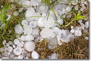
Hail is a form of precipitation which is recognized by large solid balls or
clumps of ice. Hail is created by thunderstorm clouds with strong updrafts of wind.
As the hailstones remain in the updraft, ice is deposited onto them until their
weight becomes heavy enough for them to fall to the earth's surface.
Hail storms can cause significant damage to crops, aircrafts, and man-made structures,
despite the fact that the duration is usually less than ten minutes.
Next Topic: Hole Punch Clouds
Weather Topic: What are Mammatus Clouds?
Home - Education - Cloud Types - Mammatus Clouds
 Next Topic: Nimbostratus Clouds
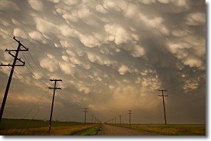
A mammatus cloud is a cloud with a unique feature which resembles
a web of pouches hanging along the base of the cloud.
In the United States, mammatus clouds tend to form in the warmer months, commonly
in the Midwest and eastern regions.
While they usually form at the bottom of a cumulonimbis cloud, they can also form
under altostratus, altocumulus, stratocumulus, and cirrus clouds. Mammatus clouds
warn that severe weather is close.
Next Topic: Nimbostratus Clouds
Current conditions powered by WeatherAPI.com


