Weather Alert in Washington
Fire Weather Watch issued July 28 at 9:46PM PDT until July 30 at 11:00PM PDT by NWS Pendleton OR
AREAS AFFECTED: East Washington South Central Cascade Mountains
DESCRIPTION: ...RED FLAG WARNING IN EFFECT FROM 2 PM TO 11 PM PDT TUESDAY FOR ABUNDANT LIGHTNING... ...FIRE WEATHER WATCH IN EFFECT FROM TUESDAY AFTERNOON THROUGH TUESDAY EVENING FOR ABUNDANT LIGHTNING... .Elevated fire weather concerns due to thunderstorms and continued hot and dry conditions through midweek. While these storms may produce wetting rains, there is still high confidence in the probability of isolated dry thunderstorms embedded both Tuesday and Wednesday. Daytime RHs will be in the teens to low 20s. Gusty and erratic winds can occur around thunderstorms with gusts up to 45-60 mph. The National Weather Service in Pendleton has issued a Fire Weather Watch for abundant lightning, which is in effect from Wednesday afternoon through Wednesday evening. * AFFECTED AREA...Fire Weather Zone 695 East Washington South Central Cascade Mountains. * TIMING...From Wednesday afternoon through Wednesday evening. * IMPACTS...Any fire that develops will catch and spread quickly. Outdoor burning is not recommended. * THUNDERSTORMS...Scattered coverage with abundant lightning as well as 10-35% chances of dry isolated storms embedded. * OUTFLOW WINDS...Gusty erratic winds up to 40-55 mph.
INSTRUCTION: A Fire Weather Watch means that critical fire weather conditions are forecast to occur. Listen for later forecasts and possible Red Flag Warnings.
Want more detail? Get the Complete 7 Day and Night Detailed Forecast!
Current U.S. National Radar--Current
The Current National Weather Radar is shown below with a UTC Time (subtract 5 hours from UTC to get Eastern Time).

National Weather Forecast--Current
The Current National Weather Forecast and National Weather Map are shown below.

National Weather Forecast for Tomorrow
Tomorrow National Weather Forecast and Tomorrow National Weather Map are show below.

North America Water Vapor (Moisture)
This map shows recent moisture content over North America. Bright and colored areas show high moisture (ie, clouds); brown indicates very little moisture present; black indicates no moisture.

Weather Topic: What are Stratus Clouds?
Home - Education - Cloud Types - Stratus Clouds
 Next Topic: Wall Clouds
Stratus clouds are similar to altostratus clouds, but form at a
lower altitude and are identified by their fog-like appearance, lacking the
distinguishing features of most clouds.
Stratus clouds are wider than most clouds, and their base has a smooth, uniform
look which is lighter in color than a nimbostratus cloud.
The presence of a stratus cloud indicates the possibility of minor precipitation,
such as drizzle, but heavier precipitation does not typically arrive in the form
of a stratus cloud.
Next Topic: Wall Clouds
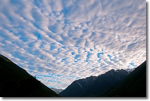
Weather Topic: What are Altocumulus Clouds?
Home - Education - Cloud Types - Altocumulus Clouds
 Next Topic: Altostratus Clouds
Similar to cirrocumulus clouds, altocumulus clouds are
characterized by cloud patches. They are distinguished by larger cloudlets
than cirrocumulus clouds but are still smaller than stratocumulus clouds.
Altocumulus clouds most commonly form in middle altitudes (between 2 and 5 km)
and may resemble, at times, the shape of a flying saucer.
These uncommon formations, called altocumulus lenticularis, are created by uplift
in the atmosphere and are most often seen in close proximity to mountains.
Next Topic: Altostratus Clouds
Current conditions powered by WeatherAPI.com


