Weather Alert in Washington
Fire Weather Watch issued July 28 at 9:46PM PDT until July 30 at 11:00PM PDT by NWS Pendleton OR
AREAS AFFECTED: East Washington South Central Cascade Mountains
DESCRIPTION: ...RED FLAG WARNING IN EFFECT FROM 2 PM TO 11 PM PDT TUESDAY FOR ABUNDANT LIGHTNING... ...FIRE WEATHER WATCH IN EFFECT FROM TUESDAY AFTERNOON THROUGH TUESDAY EVENING FOR ABUNDANT LIGHTNING... .Elevated fire weather concerns due to thunderstorms and continued hot and dry conditions through midweek. While these storms may produce wetting rains, there is still high confidence in the probability of isolated dry thunderstorms embedded both Tuesday and Wednesday. Daytime RHs will be in the teens to low 20s. Gusty and erratic winds can occur around thunderstorms with gusts up to 45-60 mph. The National Weather Service in Pendleton has issued a Fire Weather Watch for abundant lightning, which is in effect from Wednesday afternoon through Wednesday evening. * AFFECTED AREA...Fire Weather Zone 695 East Washington South Central Cascade Mountains. * TIMING...From Wednesday afternoon through Wednesday evening. * IMPACTS...Any fire that develops will catch and spread quickly. Outdoor burning is not recommended. * THUNDERSTORMS...Scattered coverage with abundant lightning as well as 10-35% chances of dry isolated storms embedded. * OUTFLOW WINDS...Gusty erratic winds up to 40-55 mph.
INSTRUCTION: A Fire Weather Watch means that critical fire weather conditions are forecast to occur. Listen for later forecasts and possible Red Flag Warnings.
Want more detail? Get the Complete 7 Day and Night Detailed Forecast!
Current U.S. National Radar--Current
The Current National Weather Radar is shown below with a UTC Time (subtract 5 hours from UTC to get Eastern Time).

National Weather Forecast--Current
The Current National Weather Forecast and National Weather Map are shown below.

National Weather Forecast for Tomorrow
Tomorrow National Weather Forecast and Tomorrow National Weather Map are show below.

North America Water Vapor (Moisture)
This map shows recent moisture content over North America. Bright and colored areas show high moisture (ie, clouds); brown indicates very little moisture present; black indicates no moisture.

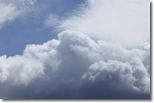
Weather Topic: What are Nimbostratus Clouds?
Home - Education - Cloud Types - Nimbostratus Clouds
 Next Topic: Precipitation
A nimbostratus cloud is similar to a stratus cloud in its formless,
smooth appearance. However, a nimbostratus cloud is darker than a stratus cloud,
because it is thicker.
Unlike a stratus cloud, a nimbostratus cloud typically brings with it the threat
of moderate to heavy precipitation. In some cases, the precipitation may evaporate
before reaching the ground, a phenomenon known as virga.
Next Topic: Precipitation
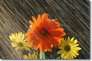
Weather Topic: What is Rain?
Home - Education - Precipitation - Rain
 Next Topic: Shelf Clouds
Precipitation in the form of water droplets is called rain.
Rain generally has a tendency to fall with less intensity over a greater period
of time, and when rainfall is more severe it is usually less sustained.
Rain is the most common form of precipitation and happens with greater frequency
depending on the season and regional influences. Cities have been shown to have
an observable effect on rainfall, due to an effect called the urban heat island.
Compared to upwind, monthly rainfall between twenty and forty miles downwind of
cities is 30% greater.
Next Topic: Shelf Clouds
Current conditions powered by WeatherAPI.com


