Weather Alert in Washington
Fire Weather Watch issued July 28 at 9:46PM PDT until July 30 at 11:00PM PDT by NWS Pendleton OR
AREAS AFFECTED: East Washington South Central Cascade Mountains
DESCRIPTION: ...RED FLAG WARNING IN EFFECT FROM 2 PM TO 11 PM PDT TUESDAY FOR ABUNDANT LIGHTNING... ...FIRE WEATHER WATCH IN EFFECT FROM TUESDAY AFTERNOON THROUGH TUESDAY EVENING FOR ABUNDANT LIGHTNING... .Elevated fire weather concerns due to thunderstorms and continued hot and dry conditions through midweek. While these storms may produce wetting rains, there is still high confidence in the probability of isolated dry thunderstorms embedded both Tuesday and Wednesday. Daytime RHs will be in the teens to low 20s. Gusty and erratic winds can occur around thunderstorms with gusts up to 45-60 mph. The National Weather Service in Pendleton has issued a Fire Weather Watch for abundant lightning, which is in effect from Wednesday afternoon through Wednesday evening. * AFFECTED AREA...Fire Weather Zone 695 East Washington South Central Cascade Mountains. * TIMING...From Wednesday afternoon through Wednesday evening. * IMPACTS...Any fire that develops will catch and spread quickly. Outdoor burning is not recommended. * THUNDERSTORMS...Scattered coverage with abundant lightning as well as 10-35% chances of dry isolated storms embedded. * OUTFLOW WINDS...Gusty erratic winds up to 40-55 mph.
INSTRUCTION: A Fire Weather Watch means that critical fire weather conditions are forecast to occur. Listen for later forecasts and possible Red Flag Warnings.
Want more detail? Get the Complete 7 Day and Night Detailed Forecast!
Current U.S. National Radar--Current
The Current National Weather Radar is shown below with a UTC Time (subtract 5 hours from UTC to get Eastern Time).

National Weather Forecast--Current
The Current National Weather Forecast and National Weather Map are shown below.

National Weather Forecast for Tomorrow
Tomorrow National Weather Forecast and Tomorrow National Weather Map are show below.

North America Water Vapor (Moisture)
This map shows recent moisture content over North America. Bright and colored areas show high moisture (ie, clouds); brown indicates very little moisture present; black indicates no moisture.

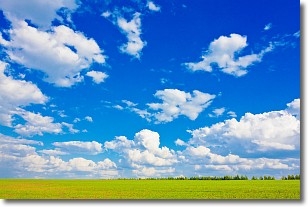
Weather Topic: What are Cumulus Clouds?
Home - Education - Cloud Types - Cumulus Clouds
 Next Topic: Drizzle
Cumulus clouds are fluffy and textured with rounded tops, and
may have flat bottoms. The border of a cumulus cloud
is clearly defined, and can have the appearance of cotton or cauliflower.
Cumulus clouds form at low altitudes (rarely above 2 km) but can grow very tall,
becoming cumulus congestus and possibly the even taller cumulonimbus clouds.
When cumulus clouds become taller, they have a greater chance of producing precipitation.
Next Topic: Drizzle
Weather Topic: What is Evaporation?
Home - Education - Precipitation - Evaporation
 Next Topic: Fog
Evaporation is the process which returns water from the earth
back to the atmosphere, and is another crucial process in the water cycle.
Evaporation is the transformation of liquid into gas, and it happens because
molecules are excited by the application of energy and turn into vapor.
In order for water to evaporate it has to be on the surface of a body of water.
Next Topic: Fog
Current conditions powered by WeatherAPI.com


