Weather Alert in North Carolina
High Wind Watch issued February 5 at 8:57PM EST until February 7 at 7:00PM EST by NWS Greenville-Spartanburg SC
AREAS AFFECTED: Avery; Alexander; Yancey; Mitchell; Buncombe; Southern Jackson; Transylvania; Henderson; Caldwell Mountains; Greater Caldwell; Burke Mountains; Greater Burke; McDowell Mountains; Eastern McDowell; Rutherford Mountains; Greater Rutherford; Polk Mountains; Eastern Polk; Greenville Mountains
DESCRIPTION: * WHAT...Northwest winds 20 to 30 mph with gusts up to 65 mph possible. * WHERE...Portions of western North Carolina and Upstate South Carolina. * WHEN...From Friday evening through Saturday evening. * IMPACTS...Damaging winds could blow down trees and power lines. Widespread power outages are possible. Travel could be difficult, especially for high profile vehicles. * ADDITIONAL DETAILS...The strong winds will result in cold wind chills across the mountains early Saturday morning, and some blowing snow near the Tennessee border.
INSTRUCTION: Be prepared for possible power outages. Take time now to fasten or shelter loose objects in a safe location prior to the onset of high winds. Stay tuned to NOAA Weather Radio or your favorite source of weather information for the latest updates. Additional details can be found at www.weather.gov/gsp.
Want more detail? Get the Complete 7 Day and Night Detailed Forecast!
Current U.S. National Radar--Current
The Current National Weather Radar is shown below with a UTC Time (subtract 5 hours from UTC to get Eastern Time).

National Weather Forecast--Current
The Current National Weather Forecast and National Weather Map are shown below.

National Weather Forecast for Tomorrow
Tomorrow National Weather Forecast and Tomorrow National Weather Map are show below.

North America Water Vapor (Moisture)
This map shows recent moisture content over North America. Bright and colored areas show high moisture (ie, clouds); brown indicates very little moisture present; black indicates no moisture.

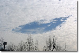
Weather Topic: What are Hole Punch Clouds?
Home - Education - Cloud Types - Hole Punch Clouds
 Next Topic: Mammatus Clouds
A hole punch cloud is an unusual occurrence when a disk-shaped
hole appears in a cirrostratus, cirrocumulus, or altocumulus cloud.
When part of the cloud forms ice crystals, water droplets in the surrounding area
of the cloud evaporate. The effect of this process produces a large elliptical
gap in the cloud. The hole punch cloud formation is rare, but it is not specific
to any geographic area.
Other names which have been used to describe this phenomena include fallstreak hole,
skypunch, and cloud hole.
Next Topic: Mammatus Clouds
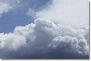
Weather Topic: What are Nimbostratus Clouds?
Home - Education - Cloud Types - Nimbostratus Clouds
 Next Topic: Precipitation
A nimbostratus cloud is similar to a stratus cloud in its formless,
smooth appearance. However, a nimbostratus cloud is darker than a stratus cloud,
because it is thicker.
Unlike a stratus cloud, a nimbostratus cloud typically brings with it the threat
of moderate to heavy precipitation. In some cases, the precipitation may evaporate
before reaching the ground, a phenomenon known as virga.
Next Topic: Precipitation
Current conditions powered by WeatherAPI.com


