Weather Alert in Louisiana
Flood Warning issued April 28 at 8:44PM CDT until May 10 at 10:00AM CDT by NWS Jackson MS
AREAS AFFECTED: Concordia, LA; Adams, MS; Wilkinson, MS
DESCRIPTION: ...The Flood Warning continues for the following rivers in Mississippi...Louisiana...Arkansas... Mississippi River At Vicksburg affecting Madison, Tensas, Claiborne, Jefferson and Warren Counties. Mississippi River At Natchez affecting Concordia, Wilkinson and Adams Counties. Mississippi River Near Greenville affecting Issaquena, East Carroll, Washington and Chicot Counties. Mississippi River Near Arkansas City affecting Bolivar, Washington, Chicot and Desha Counties. * WHAT...Moderate flooding is occurring and moderate flooding is forecast. * WHERE...Mississippi River at Natchez. * WHEN...Until Saturday, May 10. * IMPACTS...At 56.0 feet, Bourke Road which is south of Natchez is underwater. Residents will have to boat into their homes. * ADDITIONAL DETAILS... - At 8:00 PM CDT Monday the stage was 55.7 feet. - Forecast...The river is expected to crest near 55.8 feet tomorrow morning. - Flood stage is 48 feet.
INSTRUCTION: Turn around, don't drown when encountering flooded roads. Most flood deaths occur in vehicles. Motorists should not attempt to drive around barricades or drive cars through flooded areas. The next statement will be issued Tuesday morning at 845 AM CDT.
Want more detail? Get the Complete 7 Day and Night Detailed Forecast!
Current U.S. National Radar--Current
The Current National Weather Radar is shown below with a UTC Time (subtract 5 hours from UTC to get Eastern Time).

National Weather Forecast--Current
The Current National Weather Forecast and National Weather Map are shown below.

National Weather Forecast for Tomorrow
Tomorrow National Weather Forecast and Tomorrow National Weather Map are show below.

North America Water Vapor (Moisture)
This map shows recent moisture content over North America. Bright and colored areas show high moisture (ie, clouds); brown indicates very little moisture present; black indicates no moisture.

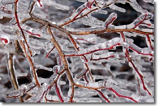
Weather Topic: What is Freezing Rain?
Home - Education - Precipitation - Freezing Rain
 Next Topic: Graupel
Freezing rain is a condition where precipitation which has fallen in the form of
water droplets reaches temperatures which are below freezing and freezes upon
coming into contact
with surface objects. The result of this precipitation is a glaze of ice which
can be damaging to plants and man-made structures. A severe onset of freezing
rain which results in a very thick glaze of ice is known as an ice storm.
Next Topic: Graupel
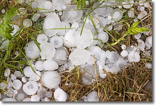
Weather Topic: What is Hail?
Home - Education - Precipitation - Hail
 Next Topic: Hole Punch Clouds
Hail is a form of precipitation which is recognized by large solid balls or
clumps of ice. Hail is created by thunderstorm clouds with strong updrafts of wind.
As the hailstones remain in the updraft, ice is deposited onto them until their
weight becomes heavy enough for them to fall to the earth's surface.
Hail storms can cause significant damage to crops, aircrafts, and man-made structures,
despite the fact that the duration is usually less than ten minutes.
Next Topic: Hole Punch Clouds
Current conditions powered by WeatherAPI.com


