Weather Alert in New Mexico
Fire Weather Watch issued June 15 at 12:24PM MDT until June 17 at 8:00PM MDT by NWS El Paso Tx/Santa Teresa NM
AREAS AFFECTED: Southwest Mountains; Southwest Deserts and Lowlands; South Central Lowlands And Southern Rio Grande Valley
DESCRIPTION: ...NEAR CRITICAL FIRE WEATHER CONDITIONS TUESDAY FOR PORTIONS OF SOUTHERN NEW MEXICO... .A passing upper-level trough will result in breezy winds from the west on Tuesday across southern New Mexico. 20-foot winds near 20 mph are expected Tuesday afternoon with gusts to 30 to 35 mph. Although the winds are not very strong, fuels are critically dry across the area and relative humidity will be near 5 percent. These factors combined with the ongoing wildfires in the Gila Region will result in near-critical fire weather conditions on Tuesday. The National Weather Service in El Paso Tx/Santa Teresa has issued a Fire Weather Watch for near critical fire weather conditions, which is in effect from Tuesday afternoon through Tuesday evening. * AFFECTED AREA...Fire Weather Zone 110 Southwest Mountains/Gila NF/Apache NF/GLZ, Fire Weather Zone 111 Southwest Deserts and Lowlands/Las Cruces BLM/GLZ and Fire Weather Zone 112 South Central Lowlands and Southern Rio Grande Valley/BLM/GLZ. * TIMING...Noon to 8 PM Tuesday. * WINDS...West 15 to 25 mph with gusts up to 35 mph. * RELATIVE HUMIDITY...As low as 5 percent. * TEMPERATURES...Up to 108. * EXPERIMENTAL RFTI...4 to 5 or Near Critical to Critical. * IMPACTS...Any fires that develop will likely spread rapidly. Outdoor burning is not recommended.
INSTRUCTION: A Fire Weather Watch means that critical fire weather conditions are forecast to occur. Listen for later forecasts and possible Red Flag Warnings.
Want more detail? Get the Complete 7 Day and Night Detailed Forecast!
Current U.S. National Radar--Current
The Current National Weather Radar is shown below with a UTC Time (subtract 5 hours from UTC to get Eastern Time).

National Weather Forecast--Current
The Current National Weather Forecast and National Weather Map are shown below.

National Weather Forecast for Tomorrow
Tomorrow National Weather Forecast and Tomorrow National Weather Map are show below.

North America Water Vapor (Moisture)
This map shows recent moisture content over North America. Bright and colored areas show high moisture (ie, clouds); brown indicates very little moisture present; black indicates no moisture.

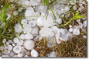
Weather Topic: What is Hail?
Home - Education - Precipitation - Hail
 Next Topic: Hole Punch Clouds
Hail is a form of precipitation which is recognized by large solid balls or
clumps of ice. Hail is created by thunderstorm clouds with strong updrafts of wind.
As the hailstones remain in the updraft, ice is deposited onto them until their
weight becomes heavy enough for them to fall to the earth's surface.
Hail storms can cause significant damage to crops, aircrafts, and man-made structures,
despite the fact that the duration is usually less than ten minutes.
Next Topic: Hole Punch Clouds
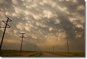
Weather Topic: What are Mammatus Clouds?
Home - Education - Cloud Types - Mammatus Clouds
 Next Topic: Nimbostratus Clouds
A mammatus cloud is a cloud with a unique feature which resembles
a web of pouches hanging along the base of the cloud.
In the United States, mammatus clouds tend to form in the warmer months, commonly
in the Midwest and eastern regions.
While they usually form at the bottom of a cumulonimbis cloud, they can also form
under altostratus, altocumulus, stratocumulus, and cirrus clouds. Mammatus clouds
warn that severe weather is close.
Next Topic: Nimbostratus Clouds
Current conditions powered by WeatherAPI.com


